Chances for getting a heavy soaking rain in Duluth and Superior tonight have diminished considerably!
-Remnants of Tropical Storm Crystobal and its associated heavy rainfall should slide mostly south/east of Duluth and Superior tonight, while additional rain develops off to the west across central into northeast Minnesota, but the heavier rain within that band looks like it will mostly stay W-NW of Duluth tonight.
-So that leaves the Twin Ports in between two areas of heavier rain, again!
-Will likely get at least a little rain at times in Duluth and Superior tonight and Wednesday, but I’m not expecting very much.
-Since January 1st, Duluth is running -4.15″ below normal in precipitation, and with no significant rain events looking likely for the next week or so, this deficit will only get larger.
-The good news is will finally get rid of the damn northeast winds in Duluth for Wednesday and Thursday, so while the rest of the Northland will be cooling down, temperatures near Lake Superior will warm up thanks to the wind shift to the NW, looks like will be in the 60s for highs below the hill in Duluth Wednesday and Thursday.
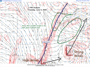
A ton of moisture in the atmosphere this afternoon from southern Minnesota to central Illinois with precipitable water of 1.50 to 2.30″. This moisture will lift NE tonight producing a risk for heavy rain in southeast portions of northwest Wisconsin.
Source: https://www.spc.noaa.gov/

Note: Radar loop below ends at 4:05 PM Tuesday, June 9, 2020.
Rain lifting N-NE across southeast and far eastern Minnesota and western Wisconsin with other scattered showers and thunderstorms developing over central Minnesota.
Source: https://weather.cod.edu

Simulated radar forecast from 7 PM Tuesday to 7 PM Wednesday.
Two areas of locally heavy rainfall possible tonight, one in northwest Wisconsin, the other across north-central and northeast Minnesota. Lingering showers for Wednesday along with gusty NW winds of 15 to 35 mph.
Source: 18z NAM 3km model 6.9.2020; https://weathermodels.com

A look at how much rain could fall through late Wednesday afternoon. Note: I have major doubts that Duluth will get a quarter to half inch of rain by tomorrow evening, I’m thinking less, but models or apps are never wrong!
…Flash Flood Watch is in effect through late tonight for southeast portions of northwest Wisconsin including the cities of Ashland, Glidden, Butternut, Hurley, Gile, Hayward and Winter…
Source: https://lab.weathermodels.com

Here comes Cristobal!
What’s left of once Tropical Storm Cristobal which made landfall in Louisiana this past weekend is moving quickly NE across eastern Iowa this afternoon.
Source: Goes-16 visible imagery; 6.9.2020; https://weather.cod.edu

And a look at Cristobal on Goes-16 water vapor imagery from Tuesday, June 9, 2020.

Cristobal will become the farthest northwest a tropical system has ever gotten in North America! Crazy times!

It’s been an active last few days in terms of severe weather across the Rockies, Western High Plains and Northern Plains.
Storm Reports maps from June 6-8, 2020.
Blue dots=Damaging Wind reports
Green dots=Large Hail reports
Red dots=Tornado reports
Source: https://www.spc.noaa.gov


Severe weather, a tropical storm, and yes even some snow this week, it’s been a crazy last few days of weather across the U.S.
Source: https://www.pivotalweather.com

Still looking at a chance for some snow or a rain/snow mix across portions of Ontario, and possibly even over far northern Lake Superior on Thursday (snow in blue colors on loop below)
Source: 18z NAM model 6.9.2020; https://weather.cod.edu

Looks pretty dry after Wednesday across most of the Northland with below normal precipitation forecast through June 24th.
Source: 12z European ensemble model 6.9.2020; https://weathermodels.com

Thanks for reading!
Tim
Leave a Reply