Looking at a dry weekend across the Northland, but it will be on the cool side, especially near Lake Superior where daytime highs Saturday and Sunday are forecast to be in the 50s to lower 60s with easterly breezes at 5 to 15 mph with higher gusts. Farther inland from Lake Superior (Roughly 20 miles or so) high temps Saturday are forecast to be in the mid 60s to low 70s with highs on Sunday in the 70s, winds southeast 5 to 15 mph with gustier winds of 15 to 25 mph for Sunday.
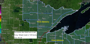
*Frost Advisory* issued for all of northeast Minnesota and most of northwest Wisconsin from Midnight tonight to 7 AM Saturday.
*Some cities included in the frost advisory are – International Falls, Bigfork, Grand Rapids, Cook, Hibbing, Duluth, Cloquet, Moose Lake, Ely, Two Harbors, Isabella, Silver Bay, Grand Marais, Superior, Washburn, Bayfield, Ashland, Hurley, Gile, Hayward and Winter.
*Temperatures in the lower to middle 30s will result in frost formation overnight. Note: The greatest chance for frost is slightly inland from Lake Superior, frost is not expected along the immediate shoreline.
*Impacts: Frost could kill sensitive outdoor vegetation if left uncovered.
Record or near record cold is possible over the Northland Saturday morning.
Record Low Temperatures for June 13th, and the year/s they were set.
Hibbing, MN: 28 degrees (2019)
Duluth, MN: 32 degrees (1969 and 1962)
International Falls, MN: 33 degrees (1969)
Brainerd, MN: 38 degrees (2019)
Low Temperature Reports from Friday morning, June 12, 2020
Source: https://www.weather.gov/dlh/
Seagull Lake, MN: 30 F
Crane Lake, MN: 32 F
Ely, MN: 34 F
Isabella, MN: 34 F
Grand Marais Airport: 34 F
Wolf Ridge, MN: 35 F
Embarrass, MN: 37 F
Hurley, WI: 39 F
Bigfork, MN: 39 F
Cook, MN: 39 F
Ashland, WI: 40 F
Northome, MN: 40 F
Eveleth, MN: 40 F
Our next chance for some rain may come Sunday night or Monday morning as a warmer and more humid air mass begins to build NE into the upper Midwest. There is a chance that much of the Northland will have high temps in the 80s and possibly even into the lower 90s next Tuesday and Wednesday. Whether or not this warmth will be felt near Lake Superior is uncertain at this time as it will depend on how the wind direction sets up during the early to middle portion of next week.
Thanks for reading!
Tim
Leave a Reply