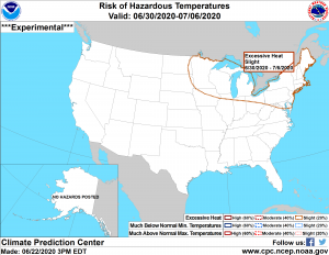
The Climate Prediction Center has highlighted all of Minnesota and Wisconsin in a Slight Risk (20%) for excessive heat for the June 30th to July 6th time frame.
This is still a ways out, but the long range ensemble models (EPS and GEFS) have been hinting at a very warm to hot open to July across the upper Midwest and Great Lakes, this will be one thing to keep an eye on this week to see if computer models continue to show this, or if they back away from it.
Source: 12z European ensemble model 6.22.2020; https://weathermodels.com

The potential is there for widespread 80s and 90s in the Northland next week along with tropical dew points in the mid 60s to mid 70s! Whether or not this type of heat and humidity only sticks around a day or two, or if it lingers most of next week is uncertain at the moment, as is the potential for a lake wind at times which would keep it a tad cooler at times closer to Lake Superior next week.
Source: 12z European ensemble model 6.22.2020

A wide range in precipitation totals so far this year, ranging from around 2 inches over central North Dakota to around 40 inches over parts of Tennessee.
Source: https://mrcc.illinois.edu
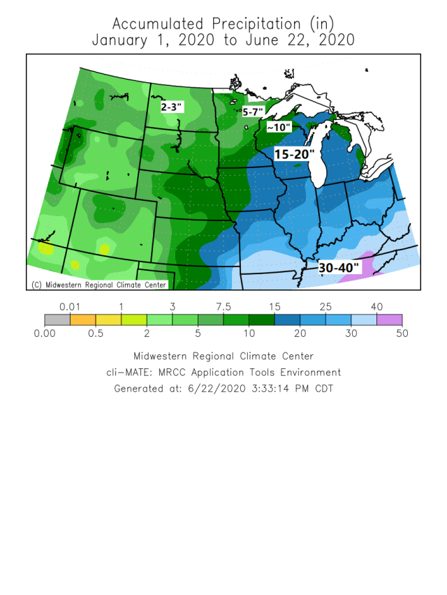
Yellow and orange areas on the map below represent well below normal precipitation totals so far this year, while the green areas represent above normal precipitation totals.

| Precipitation Totals and their Departure from Normal for 2020 (January 1 to June 21) Note: Around 2 inches of precip so far this year at Bismarck, North Dakota while Marquette, Michigan has had nearly 20 inches of precipitation thru June 21. Bismarck, ND: 2.21″ (-5.49″ below normal) Brainerd, MN: 5.72″ (-5.97″ below normal) Fargo, ND: 5.80″ (-3.70″ below normal) Duluth, MN: 5.92″ (-5.84″ below normal) St. Cloud, MN: 6.85″ (-4.39″ below normal) International Falls, MN: 6.99″ (-2.18″ below normal) Minneapolis/St. Paul, MN: 14.02″ (+1.50″ above normal) Eau Claire, WI: 14.35″ (+1.81″ above normal) Green Bay, WI: 17.00″ (+4.61″ above normal) Marquette, MI: 19.52″ (+3.83″ above normal) |
We won’t be seeing much change in the pattern through midweek as an upper level low/trough and NW flow aloft remains over the upper Midwest, Great Lakes and Ontario province.

Widespread clouds over northeast Minnesota and northwest Wisconsin today, but Tuesday should feature a little more sun compared to what we saw on Monday, but still a fair amount of clouds around as well.
Source: Goes-16 visible satellite loop ~1:30 to ~4:30 PM, Monday, June 22, 2020; https://weather.cod.edu

Simulated radar forecast valid from 7 PM Monday to 7 AM Wednesday
We’re only looking at isolated shower coverage across the Northland this evening, and again Tuesday afternoon-evening, and there may also be a stray afternoon thunderstorm on Tuesday as we get a little CAPE to build into the Northland. Highs on Tuesday are forecast to be in the 70s with a north to northwest wind 10 to 20 mph.
Source: 18z NAM 3km model 6.22.2020; https://weathermodels.com

This is pretty interesting!
Dust originating over the Sahara Desert in Africa is forecast to impact much of the southern U.S. by mid to late week before possibly spreading farther north/east by this weekend.
Dust model forecast below runs from Monday evening, June 22nd, 2020 thru the evening of July 1st, 2020.
Source: NASA GEOS-5 model 6.21.2020; https://weathermodels.com

Thanks for reading!
Tim
Leave a Reply