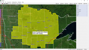
A Severe Thunderstorm Watch has been issued for northern Minnesota until 2 AM CDT Tuesday (yellow shaded area on the map)
Source: https://www.spc.noaa.gov/
Primary Threats include
-Scattered damaging wind gusts to 70 mph likely.
-Scattered large hail and isolated very large hail events to 2 inches in diameter possible.
-A tornado or two possible.
This Severe Thunderstorm Watch includes the following cities in northern Minnesota
International Falls…Bigfork…Grand Rapids…Walker…Cass Lake…Brainerd…Aitkin…McGregor…Hill City…Duluth…Hibbing…Cook…Orr…Ely…Cloquet…and Moose Lake.
Remember a severe thunderstorm watch means conditions are favorable for severe thunderstorms in and close to the watch area. Persons in these areas should be on the lookout for threatening weather conditions and listen for later statements and possible warnings. Severe thunderstorms can and occasionally do produce tornadoes.
Thanks for reading!
Tim
Leave a Reply