A significant severe weather threat exists late tonight into early Saturday morning over much of the Northland with scattered to widespread severe thunderstorms possibly producing significant damage.
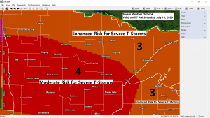
There is a Moderate Risk and Enhanced Risk for Severe Thunderstorms in place across the entire Northland for tonight. Note: A moderate risk isn’t issued very often by the Storm Prediction Center. A moderate risk is a 4 out of 5 on the risk scale!

Hazards for late tonight include
Wind gusts up to 70+ mph. Significant wind damage is possible.
Large hail to 1 inch in diameter or quarter size.
Tornadoes are also possible tonight into early Saturday morning.
Stay alert, follow the forecast and make sure you have a safe place to take shelter if storms threaten.
Watches and warnings could be issued for parts of the Northland tonight.
Know the difference! A watch means conditions are favorable for dangerous storms while a warning means the threat is imminent. Take shelter now!
Some great info. from the National Weather Service in Duluth, Minnesota ahead of tonight’s severe weather – “If you are staying in or near the following Minnesota State Parks, have a plan for shelter when storms come through tonight, or consider cancelling camping plans! Schoolcraft, Savanna Portage, Crow Wing, Moose Lake, Jay Cooke, Banning, St. Croix and more”.
Image below from the National Weather Service Grand Forks, ND

Source: https://www.spc.noaa.gov/


As I mentioned above, there is a chance for isolated tornadoes across most of the Northland late tonight, these won’t be your normal tornadoes, the ones that may develop tonight will be quick spin-ups on the leading edge of what’s expected to be a forward propagating line of storms (bow echo)

One of the ingredients for tonight’s severe weather event is the tropical air mass which is lifting north out of southern and central Minnesota today as southerly winds in the low levels of the atmosphere transport 70 to 75 degree dew points northward into our area.

Another ingredient needed for severe weather is instability or CAPE. Check out the CAPE gradient that is in place this afternoon across the northern Plains and upper Midwest.
Very unstable air across the Dakotas into the southern half of Minnesota with CAPE of 3000-5000 J/kg, and this unstable air mass will be lifting N-NE into the Northland as southerly low level winds help to bring in this high octane air mass.

Goes-16 visible satellite loop from Friday, July 17, 2020 (ending ~1:25 PM CT)
Note the clouds across southern Minnesota and how they are lifting north, these clouds mark the leading edge of a very humid and unstable air mass. The dew point was 58 degrees at Brainerd, Minnesota at 1 PM today, while a little further south at Little Falls, their dew point was 72 degrees at 1 PM today.
Source: https://weather.cod.edu/

Severe thunderstorms have already developed early this afternoon across northern North Dakota, and these storms are likely the beginnings of what could be a widespread swath of damaging winds as they move into the Northland later tonight.
Radar loop thru 1:35 PM CT, Friday, July 17, 2020.

Breaking down the timing on when storms may move through the Northland tonight. Note: Times are approximate and may change a bit if storms slow down or speed up.
*Midnight to 2 AM for western areas including International Falls, Bigfork, Grand Rapids, Walker and Brainerd.
*2 to 4 AM farther east including Hibbing, Ely, Two Harbors, Duluth and the Interstate 35 corridor.
*3 to 5 AM for all of northwest Wisconsin.
17z HRRR model run simulated radar forecast from 7 PM Friday to 6 AM Saturday.
Source: https://weathermodels.com/

Here’s a look at the Hop-WRF-ARW model Max Wind Gust potential ending at 4 AM Saturday, July 18, 2020 per its 15z (10 AM run) from Friday.
Those red and darker red colors on the map indicates potential for wind gusts of 60 to 70 mph or greater.
Source: http://www.hopwrf.info/

Thanks for reading!
Tim
Leave a Reply