Low of 47 degrees at the Duluth Airport this morning, Thursday, July 23rd, 2020. Coolest morning in Duluth since June 14th, 2020 when the low was 41 degrees.
5.21″ of rain so far this month at the Duluth Airport, this is +2.35″ above normal thru July 22nd. Note: Will need an additional 1.60 inches of rain by the end of the month to get July 2020 into the top 10 wettest Julys on record in Duluth.
Still have a precipitation deficit for the summer and for the year in Duluth with a precipitation deficit of -1.19″ below normal since June 1st, and -4.58″ below normal since January 1st, but we’re making good progress in shrinking these deficits especially when you compare it to where we were back in late June.
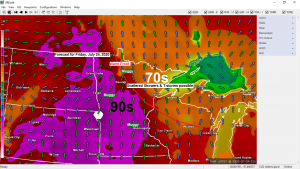
Yes it will be turning warmer the next few days, but it’s the increase in humidity/dew points that will be most noticeable in our area, not so much the temperatures as it looks like will have highs Friday and Saturday in the 70s and 80s which really isn’t too bad considering the normal highs in late July are in the upper 70s to around 80 degrees, but dew points will be climbing into the 60s and low 70s Friday afternoon, and into the upper 60s to middle 70s on Saturday making it feel pretty tropical around here.
Upper level ridge (588 decameters) covered portions of the northern Plains and upper Midwest today with the core of the heat centered over the western High Plains into parts of the Northern and Central Plains today. This heat will expand east/southeast into western, central and southern Minnesota on Friday.

Excessive heat warnings and heat advisories cover much of western, central and southern Minnesota for Friday with heat index values of 100 to around 105 degrees possible during the afternoon and evening.

A pleasant/comfortable air mass remains over northeast Minnesota and northwest Wisconsin this afternoon with dew points in the upper 40s to around 60 degrees, but things will be changing by Friday afternoon when dew points reach into the mid 60s to around 70 degrees.

…Thunderstorm Potential…
There is a chance for scattered showers and thunderstorms in northeast Minnesota and northwest Wisconsin during the day Friday due to a warm front which will be lifting NE across Minnesota. A low level jet of around 25-35 knots along and ahead of this boundary will help advect warmer, more humid and unstable air into the Northland on Friday, while some lift/forcing associated with the warm frontal boundary causes a few storms to develop. I don’t think severe weather will be a major concern with the storms on Friday, but lightning and downpours will be.
18z NAM 3km model simulated radar forecast valid from Midnight tonight to 7 PM Friday.
Source: https://weathermodels.com/

Chances for scattered showers and thunderstorms should be focused mostly to over north-central Minnesota Friday night (west/north of Duluth)
Shower and thunderstorm chances continue Saturday as a cold front moves east out of the northern Plains, and we may also be dealing with a couple of outflow boundaries near or over the Northland left over from Friday night’s activity to our west/north, and those may also help to spawn some new storms on Saturday. I have to say I’m not too impressed with Saturday’s setup in regards to severe weather potential in northeast Minnesota and northwest Wisconsin. Winds aloft look good as does the strength of a low level jet. Should have plenty of moisture in place as well, but instability looks quite a bit less compared to last weekend, and mid level lapse rates look less than ideal as well, so although scattered storms will likely occur on Saturday, the threat for severe storms looks pretty low at the moment. I think the bigger concern with the storms Saturday could be the heavy rain potential thanks to dew points in the upper 60s to middle 70s while precipitable water increases to 1.90 to 2.25″!
Update on Hurricane Douglas
11 AM HST, Thursday, July 23, 2020
Source: https://www.nhc.noaa.gov/
Douglas was located about 1235 miles east-southeast of Hilo, Hawaii and is moving west-northwest at 18 mph.
Maximum sustained winds were at 125 mph and the minimum central pressure was 959mb/28.32 inches.

Here’s the forecast track of Hurricane Douglas per National Hurricane Center. Douglas should be moving toward the Hawaiian Islands by Saturday afternoon or evening, and is forecast to pass close to Hilo on Sunday before moving west of the Islands by Monday, July 27th. Douglas is a major hurricane/category 3 storm at the moment with winds greater than 110 mph, but Douglas is forecast to weaken to a category 1 storm with winds of 74-110 mph as it moves toward Hilo later this weekend.

Thanks for reading!
Tim
Leave a Reply