Meteorological Fall begins on Tuesday, September 1st, and right on cue the weather pattern is trending fall like next week.
-More frequent and deeper low pressure systems impacting the area.
-More wind as we undergo temperature changes from day to day, mild one day, cooler the next.
-Sunday’s weather: A pleasant late summer day with highs mainly in the 70s with breezy southerly winds 10 to 20 mph. Cooler temps over the Arrowhead and North Shore as winds will be out of the east. A mix of sun and clouds are expected for Sunday, and it looks dry through the day.
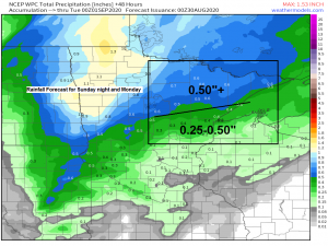
Here comes the first system which is expected to deepen as it moves over us on Monday. There should be quite a bit of lift ahead of this one along with a strengthening SSW 850mb jet of 30 to 50 knots Sunday night which will result in a warm/moist advection pattern across the Northland – Bottom line is that we should see widespread light to moderate rainfall across the area from Sunday evening through early Monday afternoon. Beginning first in far western areas late Sunday afternoon or evening, then spreading east later Sunday night. Rain wraps up from W-E Monday morning/early Monday afternoon.
Source: 12z NAM model 500mb forecast 8.29.2020; https://www.tropicaltidbits.com/

18z NAM 3km model radar forecast valid from 1 PM Sunday to 1 PM Monday.
Source: https://weathermodels.com/

Looks like will have highs in the 60s and 70s next week across the Northland which really isn’t that cool, and only a little below normal for the August 31st to September 5th time frame, and I don’t think will have to worry about any frost in northeast Minnesota or northwest Wisconsin at least through September 6th, but after that…read on!
Source: https://weathermodels.com/

What’s lurking for the second week of September is quite impressive as a large pool of chilly air sets up shop over central Canada, Northern Plains, upper Midwest and western Great Lakes – This air mass could lead to daytime highs topping out only in the 40s and 50s in northeast Minnesota and northwest Wisconsin sometime between September 7th and 12th, while a few nights of frost/freezing conditions are possible as well during the second week of September. Note: Computer models have a tendency of overdoing these early season cold shots, so will see if computer models remain consistent in showing this cold air mass, or if they begin to modify things just a bit between now and September 7th. Stay tuned.

This pattern should it verify will certainly be a cool one for the Northland – An almost winter type setup for the second week of September, but without snow, a little too early for that.

Some snow is possible at times over the next 10 days across parts of the Rockies per Euro, GFS and Canadian/GEM computer models.
Source: 12z Canadian/GEM model 8.29.2020; https://www.tropicaltidbits.com/

The outlined areas on the map picked up a quarter to half inch of rain on Friday, with one to as much as two plus inches of rain reported in southeast portions of northwest Wisconsin (Hayward Lakes vicinity)
Source: https://lab.weathermodels.com/

Rainfall Reports from Friday, August 28, 2020
Source: https://www.weather.gov/dlh/
4 W Clam Lake, WI: 2.52″
Hayward, WI: 1.54″
Hurley, WI: 0.91″
Butternut, WI: 0.85″
12 N Grand Rapids, MN: 0.45″
2 E Celina, MN: 0.26″
1.2 W Solon Springs, WI: 0.23″
Cook, MN: 0.20″
Grand Marais, MN: 0.20″
Two Harbors, MN: 0.17″
3 E Wright, MN: 0.12″
2 S Tower, MN: 0.11″
Ashland, WI: 0.09″
International Falls, MN: 0.03″
Brainerd, MN: 0.02″
Duluth Airport: 0.01″
Thanks for reading!
Tim
Leave a Reply