Our active weather pattern continues! Last night’s system which brought some showers and thunderstorms to parts of the Northland has pulled NE into Hudson Bay and Quebec this afternoon, while upstream is the next big system which is plowing ESE into the Northern Plains late this afternoon, this system will be affecting the Northland late tonight and Thursday.
*Rain showers are possible in Duluth and Superior late tonight, mainly after Midnight (a few rumbles of thunder are also possible)
*Highs on Thursday will be around 10 degrees cooler compared to Wednesday’s highs. Temps will be around 60-63 degrees Thursday afternoon in the Twin Ports.
*Isolated showers remain possible through the day Thursday, but most of the rain in Duluth should fall prior to sunrise. Will have a mix of sun/clouds on Thursday.
*Gusty southwest winds late tonight 15 to 30 mph, winds become west to northwest on Thursday with gusts of 30 to 45 mph possible.
*Gale and Storm Force Winds are likely across Lake Superior on Thursday, but with a WNW wind (offshore direction) the largest waves will be east of the North Shore over the open waters of the lake.
As for the Labor Day weekend weather across the Northland – Things don’t look too bad at the moment. Saturday continues to look dry, and Sunday may end up being dry as well, but there is quite a bit of model disagreement as we move from Saturday night into Sunday. Stay tuned.
Highs Saturday and Sunday are forecasted to be in the 60s and 70s.
Strong warm air advection will surge into the Northland this evening and overnight ahead of a strong area of low pressure which moves NE out of North Dakota – a low level jet could reach speeds of 50 to nearly 70 knots late tonight over parts of the Northland. The warm air advection will be replaced by strong cold air advection by Thursday morning as low pressure pulls away to the NE, a low level jet on the backside of the low could reach speeds of 40-60 knots for a few hours Thursday morning. An impressive system to say the least.
Source: https://www.spc.noaa.gov/

That is quite the cold front slicing SE through the Dakotas late this afternoon. 90s ahead of the front, 60s behind it.
Source: RTMA model; https://lab.weathermodels.com/

Source: Goes-16 water vapor loop from Wednesday, September 2, 2020; https://weather.cod.edu/

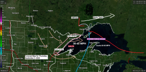
Wind gusts of 40 to 55 mph are possible across Lake Superior on Thursday as a deep area of low pressure (977-984mb) passes north of the lake.
Source: 18z NAM-Nest model 9.2.2020; https://weather.cod.edu/

Areas of rain and showers will impact much of the Northland from late this evening into early Thursday morning, this will be followed by a few pop-up showers for Thursday afternoon. Note: Isolated thunderstorms are also possible late tonight as some weak instability and a pocket of steep mid level lapse rates move over the area.
Simulated radar forecast valid from 7 PM Wednesday to 7 PM Thursday.
Source: 18z NAM 3km model 9.2.2020; https://weathermodels.com/

Greatest rainfall totals with tonight’s system are expected to be over far northern Minnesota with a half inch or more of rain possible by Thursday afternoon. Rain totals are expected to taper off further south with only trace amounts expected for the Brainerd and Hayward Lakes areas.
Source: https://lab.weathermodels.com/

| Rainfall Reports from Tuesday, September 1, 2020 Source: https://www.weather.gov/dlh/; https://mesowest.utah.edu/ International Falls, MN: 0.45″ 12 N Grand Rapids, MN: 0.42″ 3 E Orr, MN: 0.35″ Ely, MN: 0.35″ Isabella, MN: 0.34″ 2 S Tower, MN: 0.33″ Cook, MN: 0.33″ 2 E Celina, MN: 0.32″ Northome, MN: 0.31″ Cotton, MN: 0.30″ 25 E Ely, MN: 0.27″ Duluth, MN: 0.27″ Embarrass, MN: 0.22″ Hibbing, MN: 0.21″ Grand Marais, MN: 0.20″ Two Harbors, MN: 0.16″ Floodwood, MN: 0.15″ Cass Lake, MN: 0.08″ Hill City, MN: 0.04″ Moose Lake, MN: 0.03″ Washburn, WI: 0.02″ Ashland, WI: 0.02″ |
Source: https://lab.weathermodels.com/

Local Storm Reports from Tuesday, September 1, 2020
Source: https://www.weather.gov/dlh/
9:17 PM: Thunderstorm Wind Gust 49 mph. 5 E Hibbing, MN (St. Louis County)
9:05 PM: Hail 0.50 inch. 5 N Remer, MN (Cass County)
A rather interesting weather pattern may be setting up for next week. Details are still far from certain, but some of the computer models, especially the European and Canadian are trending toward a strong trough digging south through the Rockies and Plains which could lead to a strong storm system forming over those areas during the early to middle part of next week. Very warm to hot weather would be found east of the trough while cold and potentially snowy weather occurs in the colder air across the Rockies next week. Stay tuned.
Source: 12z European computer model 9.2.2020; https://weathermodels.com/

European model is a snowy one for parts of the Rockies next week with the first major snow event of the season possible in the September 7th-9th time frame.

Coldest air of the season (so far) is on the way for next week, but the coldest temps compared to normal may end up being west of our area, more so from the Rockies to the Northern Plains, with the Northland being on the east flank of this cold air mass, but all this will depend on how the trough/ridge sets up next week. Still some things for the computer models to iron out over the next few days.
Source: 12z European ensemble model 9.2.2020

Thanks for reading!
Tim
Leave a Reply