An area of low pressure along with its warm front and cold front will move quickly NE out of southern Minnesota tonight. This system will produce some rain this evening across parts of northeast Minnesota and northwest Wisconsin, and there will also be a chance for some thunderstorms this evening over northwest Wisconsin and possibly further west into east-central Minnesota as well.
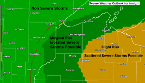
Note: A few strong to severe thunderstorms are possible through late this evening over northwest Wisconsin, with the greatest chances roughly along and east of a line from Ashland to Hayward including cities such as Cable, Winter, Loretta, Mellen, Glidden, Upson, Hurley and Mercer. Large hail of quarter to hen egg size is the primary severe weather threat this evening.
Areas of fog and drizzle will also persist through most of tonight, but these conditions will improve on Sunday as drier air along with a stronger west wind develops behind tonight’s low pressure system

Some rain this evening followed by some dry weather overnight into Sunday morning, and then will see a few showers pop-up once again for Sunday afternoon.
Note: Highs in the Northland on Sunday are forecast to be in the 50s and 60s, even cooler on Monday with highs in the mid 40s to mid 50s.
18z NAM 3km radar forecast thru 7 PM Sunday.
Source: https://weathermodels.com/

Much of the Northland is forecast to get a tenth to quarter inch of rain by Sunday evening, but up to a half inch of rain is possible over far northeast Minnesota, and a swath of a half to one inch of rain is possible covering far SE portions of northwest Wisconsin.
Source: https://lab.weathermodels.com/

Our next weather maker is moving quickly to the ENE out of the Northern Plains and into the upper Midwest and Great Lakes this afternoon – Today’s system has a lot of upper level support with RAP model analysis showing 70-80 knot 500mb winds, and >100 knot winds at 300mb spreading NE out of South Dakota.
Source: https://weather.cod.edu/

Similar to Friday’s setup, today’s setup also has very favorable wind shear in place for severe weather across north-central Wisconsin into upper Michigan with Surface-6 KM shear of 60 to around 80 knots. Along with the high shear comes enough instability (elevated CAPE up to 1000 J/kg) to create an environment conducive for a few severe storms over portions of north-central Wisconsin and upper Michigan through late this evening.

Parts of the Northland have seen a little rain today, including here in Duluth and Superior, but rainfall amounts for those that got some rain have only been in the 0.01 to around 0.10 inch range so far today.
Note: Radar loop ends at 3:33 PM, Saturday, September 26, 2020.
Source: https://weather.cod.edu/

Our weather over the next few days will be dominated by cold air aloft, a mix of sun and clouds along with chances for scattered showers, most of these showers should occur during the afternoon and early evening hours once we build up enough surface heating.
Shown below is a 500mb temperature forecast from 7 AM Sunday to 7 PM Monday per NAM model which shows H5 temps of around -20 to -25C, a pretty chilly air mass up at around 18,000 feet.
Source: https://www.pivotalweather.com/

Still looking at a very chilly air mass pouring into the Northland late next week, from around October 1st-3rd. Daytime highs late next week are forecast to only be in the 40s, and there is even a chance that a few locations struggle to make it out of the upper 30s! Along with these cold temps comes the risk for a few graupel showers, and possibly even a few snow flurries for late next week.
Source: https://www.wpc.ncep.noaa.gov/

Additional Storm Reports from Friday, September 25, 2020
Source: https://www.weather.gov/dlh/
9:15 PM: Hail 0.70 inch. 2 ENE Mercer, WI (Iron County)
9:09 PM: Hail 0.70 inch. 1 S Mercer, WI (Iron County)
9:06 PM: Hail 1.25 inch (Half dollar size hail) Mercer, WI (Iron County)
8:51 PM: Hail 0.70 inch. 2 ENE Mercer, WI (Iron County)
8:00 PM: Thunderstorm Wind Damage. 3 S Mellen, WI (Ashland County) Tree down on Highway 77.
7:55 PM: Hail 2.00 inch (Hen Egg size hail) 3 NW Morse, WI (Ashland County)
Thanks for reading!
Tim
Leave a Reply