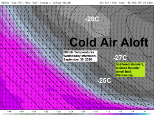
-Isolated to scattered rain showers will continue tonight and Wednesday, and we could even hear a rumble of thunder this evening and again on Wednesday thanks to some weak instability and steep mid level lapse rates passing over the area, in fact it wouldn’t surprise me if we get a few reports of small hail in the Northland this evening and again on Wednesday.
-Much colder temperatures arrive late this week into the weekend with daytime highs only in the upper 30s to upper 40s for Thursday, Friday and Saturday.
-Chance for a few snow flurries and or graupel showers Thursday and Friday.
-Warmer temps next week?
Much of the Northland has a chance to pick up around a tenth to quarter inch of rain thru early Thursday morning.
Note: Duluth needs an additional 0.23″ of precipitation by Midnight Wednesday night in order to keep September 2020 from ranking in the top 10 driest Septembers on record. We’ve had 0.82″ of precipitation so far this month in Duluth, and if September ended today it would finish as the 6th driest September on record at Duluth.
Source: https://lab.weathermodels.com/

Showers will be scattered throughout the Northland over the next 24-36 hours, but like we’ve seen the last 2 days, there will be dry hours between the showers with even some breaks in the clouds.
Here’s a look at the 18z NAM 3km radar forecast ending at 7 AM Thursday.
Source: https://weathermodels.com/

Temperatures warmed into the upper 50s to low/mid 60s across the Northland this afternoon which is close to the normal highs for September 29th.
Highs on Wednesday should mainly be in the 50s.

The average temperature at Duluth for September 2020 (thru the 28th) was 54.9 degrees or -1.1 degrees below normal.
50% of days this month have been below average, while 43% of days have been above average, while 7% of days have had an average temperature.
Here’s a look at the daily average temperature departure at Duluth, Minnesota for September 2020 (thru the 28th) above average temps in red, below average temps in blue.
Note the warming trend we’ve seen this month in Duluth after the 18th, with every day from September 19th to September 28th either above average or average.
Source: https://mesonet.agron.iastate.edu/

Another day featuring some sun, clouds and scattered showers across the area today.
Loop ends at 4:52 PM CT, Tuesday, September 29, 2020.
Source: https://weather.cod.edu/

Big time ridge out west with an upper level low to our northeast resulting in a NW flow across the upper Midwest today. Very little change in the pattern is expected through this weekend, in fact the pattern will amplify even more by late this week causing even colder air to pour south out of the Arctic.

Temps aloft will become cold enough late this week to support some frozen precipitation over parts of the Northland.
850mb temperatures are forecast to drop as low as -5 to -10C, while 925mb temperatures range from around 0 to -1C, so it will come down to near surface temps as to whether or not we see some snow flurries or just rain drops in the Thursday-Friday time frame.

Still seeing some differences in the weather models for next week, as the Euro ensemble (EPS) continues to show warmer temperatures spreading further east compared to the GEFS model.
Note: The difference would mean highs in the 60s, and maybe even a few 70s on a few days next week across the Northland per EPS guidance, while the GEFS model would keep us in the 50s, or very close to normal for early October.
Stay tuned
Source: https://weathermodels.com/

Source: https://www.tropicaltidbits.com/

Thanks for reading!
Tim
Leave a Reply