A cold and gray early October day around the Northland as highs were only in the upper 30s to middle 40s today. Note: Normal highs are in the upper 50s in early October.
Ashland broke their record cold high temperature for today, October 2nd, new record 43 degrees, old record 45 degrees set in 1944, while International Falls and Hibbing tied their record cold high temperature for today’s date, with both locations reporting a high temperature of just 40 degrees.
Highs on Saturday are expected to mainly be in the 40s, with highs Sunday in the mid 40s to low 50s.

An early season cold air mass has pushed well to the south today with the 850mb temperature contour as far south as northern Iowa east to far northern Ohio.

A cold northerly wind moving over Lake Superior caused some lake effect snow and rain showers over parts of northern Wisconsin and upper Michigan today with around a half inch of snow reported south of Houghton near Painesdale, and also near Marquette, Michigan earlier today.
Radar loop below is from ~8 AM to 5 PM Friday, October 2, 2020.
Source: https://weather.cod.edu/

Today’s weather is more typical of November and December with the widespread cloudiness out there today. I don’t think will see a whole lot of sun on Saturday, but Sunday should feature at least partial sunshine.
Source: https://weather.cod.edu/

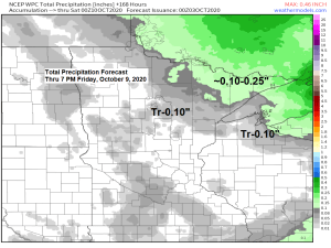
There could be a few showers at times over the Northland on Saturday into early Sunday, but no widespread soaking rains are expected, in fact many of us probably won’t see any rain at all.
Note: Some snowflakes could mix in with the rain Saturday morning over parts of north-central Minnesota into the tip of the Arrowhead (inland from Lake Superior)
18z NAM 3km radar forecast valid from 1 AM Saturday to 7 AM Sunday.
Source: https://weathermodels.com/

Note: We’ve got a few systems lined up for next week, but none of them look to produce a whole lot of rain as they move across the Northland, so drought conditions will continue until further notice, and may even worsen a bit over the next week. One thing these systems will produce is wind, and with how dry it is around here, we could see the fire danger increase a bit next week.
Drought monitor as of September 29th, 2020
8% of Minnesota is in D1 or Moderate Drought (orange areas on map) this is up from 7% last week.
45% of Minnesota is Abnormally Dry (yellow areas on map) this is up from 28% last week.
Source: https://www.cpc.ncep.noaa.gov/

19% of Wisconsin is Abnormally Dry (yellow areas on map) this is up from 9% last week.

Forecast models are in better agreement today regarding the temperature forecast for next week. It does look a little warmer across the Northland next week with daytime highs in the 50s and 60s, but the warmest temperatures when compared to normal will be found from the Rockies to western High Plains.
Source: https://weathermodels.com/

Source: https://www.tropicaltidbits.com/

Thanks for reading!
Tim
Leave a Reply