A few cold fronts will be moving through the Northland this week, but it doesn’t look like will get a whole lot of rain as these fronts move through, in fact we’re only looking at around a trace to a tenth of an inch of rain over parts of the Northland through Friday, and those chances look greatest north of a Grand Rapids to Duluth to Ashland line.
Source: https://lab.weathermodels.com/

Bulk of the energy with tonight and Monday’s system is passing north of us through Manitoba and Ontario per water vapor imagery.
Source: https://weather.cod.edu/

Only expecting a few isolated rain showers across the Northland over the next few days, but a lot of us won’t get any rain at all.
18z NAM 3km radar forecast valid from 7 PM Sunday to 7 PM Tuesday.
Source: https://weathermodels.com/

Widespread sub-freezing temperatures and a widespread heavy frost across the Northland this morning.
Cold spots this morning (not shown on the map below)
Aitkin 21 degrees
Solon Springs 21 degrees

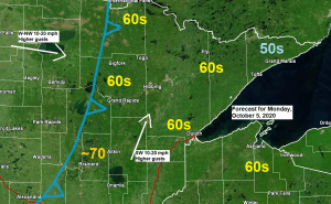
Normal highs are in the mid to upper 50s across the Northland this week, and it looks like will be in the 60s most of this week.
Source: 12z European ensemble model 10.4.2020; https://weathermodels.com/

Strong warm air advection pattern develops across the Northland on Monday causing 850mb temperatures to go from around 0C this afternoon to around +12C by Monday afternoon.

Thanks for reading!
Tim
Leave a Reply