Instability has been on the low side today with CAPE generally <500 J/kg, but a very strong jet stream over the area has led to some rather impressive dynamics today which has helped to trigger a few thunderstorms this afternoon across parts of northeast Minnesota and northwest Wisconsin, expect this activity to linger through the evening.
Most of us will stay dry Wednesday, but a few showers could develop at times mainly over north-central and northeast Minnesota, but with even less CAPE on Wednesday compared to today we shouldn’t see any thunderstorm activity in our area on Wednesday.
Thursday is looking dry, but a surge of higher elevated CAPE ahead of a northeastward moving warm front could spark a few storms in our area early Friday morning.
Temperature Forecast
Highs on Wednesday will range from the mid 50s across the north to the low and mid 60s for southern areas or generally along and south of Highway 2 in northeast Minnesota.
Highs on Thursday will be in the 50s and lower 60s, but much warmer temperatures move in for Friday with widespread 65 to 75 degree highs expected across the Northland.
Wind Forecast
Breezy conditions will continue across the Northland tonight and Wednesday as westerly winds gust to around 20 to 30 mph this evening, and to around 25 mph on Wednesday. Less wind on Thursday, but Friday could be another breezy day (sw wind)
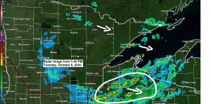
We’ve seen a few fast moving showers and thunderstorms move across parts of the Northland this afternoon with some stronger storms moving through parts of eastern Minnesota and northwest Wisconsin, and also the tip of the Arrowhead as of 5 PM, and these storms are capable of producing small hail and gusty winds, along with a brief downpour and some lightning through early this evening.
Note: Radar loop ends at 5:06 PM, Tuesday, October 6, 2020.
Source: https://weather.cod.edu/

A mild early October day with temperatures in the middle 60s to lower 70s across most of the Northland this afternoon, and its even warmer further south where temps were in the low to mid 80s this afternoon.
Note: Normal highs on today’s date are in the mid to upper 50s in northeast Minnesota and northwest Wisconsin.

Very strong winds in the upper levels of the atmosphere covered parts of the Northern Plains and upper Midwest today, and similar conditions are expected on Wednesday.
Source: https://www.spc.noaa.gov/

A rather large temperature contrast also helps to strengthen the jet stream, and we have one of those today, with 850mb temps of around -11C to our north, to as warm as +28C near Denver.

Powerhouse jet stream even shows up on visible satellite imagery today as noted by a band of clouds which stretched in a NW-SE fashion from British Columbia to central Wisconsin.
Source: https://weather.cod.edu/

18z NAM 3km radar forecast thru 7 PM Wednesday shows the isolated nature to these showers over the next 24 hours, certainly not looking at a widespread soaking rain anywhere in our area.
Source: https://weathermodels.com/

Thanks for reading!
Tim
Leave a Reply