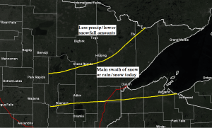
Some changes have occurred with today’s system as computer models have shifted the main swath of precipitation further south compared to what they were showing on Friday.
With this change expect lower precip/snowfall totals across northern Minnesota including for Bigfork, International Falls, Orr and Crane Lake areas.
It now looks like the central/southern portions of the Northland will receive the most precip today whether its from snow, rain or a mix, this includes the Brainerd Lakes area, Grand Rapids, Hibbing, Ely, Twin Ports, North Shore, Arrowhead, and far northern Wisconsin.
My updated snowfall forecast for today’s event.
Lowered amounts to the 1-3″ range since this looks to be a progressive system with most of the snow occurring this morning into mid-afternoon.
Still looks like 1-3″ of snow for locations above the hill in Duluth today with an inch or less in lower elevation (below the hill)
Temps warm enough where precip switches over to drizzle or light rain within about 5-10 miles of Lake Superior by this afternoon.

Winter weather advisory remains in effect for today, and has been extended further south to include Brainerd, Walker, Moose Lake, Cloquet and Duluth.
Note: The advisory for Duluth is in effect until 10 PM this evening.

Most of the snow or rain/snow mix will move through the Northland this morning into mid-afternoon. Precipitation ends from SW-NE mid to late afternoon, lingering longest in the Arrowhead.
06z NAM 3km radar forecast until Midnight tonight.

Thanks for reading!
Tim
Leave a Reply