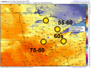
A cool early Tuesday morning will give way to very pleasant temperatures during the afternoon with highs in the mid 50s to mid 60s across northeast Minnesota and northwest Wisconsin. Should have a lot of sunshine once again on Tuesday. Note: Some locations in western/southern Minnesota could have temperatures reaching well into the 70s, possibly up to around 80 degrees Tuesday afternoon, incredible warmth for early November.
Temperatures won’t change much mid to late week as will keep a warm air mass over the Northland leading to afternoon highs in the mid 50s to mid 60s from Wednesday through the weekend. Note: There is a chance that a few locations might even hit 70 degrees on a few days through the weekend.
Will we break some warm temperature records at Duluth this week? Time will tell.
Here are the record high temperatures over the next few days
November 3rd: 73 degrees set in 1903
November 4th: 69 degrees set in 1975, tied in 2016
November 5th: 70 degrees set in 2016
November 6th: 70 degrees set in 2016
November 7th: 65 degrees set in 1874
November 8th: 69 degrees set in 1999
Note: I think our best shot at breaking a record high temp in Duluth this week will come on Saturday, November 7th, the other records should be safe this week.
| November Climate Normals and Records at Duluth, Minnesota Normal high on the 1st: 44 degrees Normal high on the 30th: 29 degrees Normal low on the 1st: 29 degrees Normal low on the 30th: 14 degrees Averages for the month Temperature: 28.8 degrees Precipitation: 2.09″ Snowfall: 13.7″ 3 days with a high temperature of at least 50 F 2 days with a sub-zero low temperature Records for the month Warmest: 40.6 degrees set in 1897 Coldest: 18.8 degrees set in 1959 Wettest: 5.08″ set in 2000 Driest: 0.09″ set in 1917 Snowiest: 50.1″ set in 1991 Least snowiest: Trace set in 1928 Astronomical Data for November Sunrise on the 1st: 6:52 AM CST Sunrise on the 30th: 7:32 AM CST Sunset on the 1st: 4:52 PM CST Sunset on the 30th: 4:22 PM CST |
| Past November Snowfall Totals at Duluth, Minnesota 2010-2019 Note: Average snowfall in November is 13.7″ 2010: 27.9″ (7th snowiest November on record) 2011: 3.7″ 2012: 10.1″ 2013: 4.7″ 2014: 16.4″ 2015: 4.4″ 2016: 8.1″ 2017: 10.5″ 2018: 12.2″ 2019: 27.7″ (8th snowiest November on record) Since 2010, 3 Novembers have had above average snowfall at Duluth (2010, 2014 and 2019) Out of those 3 years, 2 of them went on to have above average snowfall for the rest of the season, while the other had well below average snowfall. Since 2010, 7 Novembers have had below average snowfall at Duluth (2011, 2012, 2013, 2015, 2016, 2017 and 2018) Out of those 7 years, 4 of them went on to produce above average snowfall for the rest of the season, including 3 seasons which had >100″ of snow. |
After weeks of very cold temperatures, the pattern is changing in a big way! Arctic air is being pushed farther north/east this week, while warmer/Pacific air spreads east.

Today’s highs across the Northland ranged from the mid 40s to mid 50s, except in the Brainerd Lakes area where highs came within 1 to 3 degrees of 60!
60s and 70s were widespread this afternoon from the Dakotas to western/southern Minnesota.

Where is the cold air? One area is Alaska where its quite cold today with temperatures still well below zero as of early Monday afternoon. Note: Chicken, Alaska had a low of -40 degrees below zero this morning, Monday, November 2.

A quiet week of weather ahead for the Northland, but things might change a bit next week.
The general pattern is forecast to feature a deep trough over the Rockies with ridging farther east – this type of pattern can lead to the formation of strong low pressure systems over the Rockies or Plains as cold air dives south out of Canada while warm air gets pulled north.
Models, especially the GFS have been hinting at a powerful storm sometime next week which could impact portions of the upper Midwest and western Great Lakes, other models keep things farther off to the east and aren’t nearly as strong as some of the GFS solutions have been over the last few days.
Stay tuned

Tropical Storm to Hurricane Force Winds across portions of Lake Superior on Sunday, November 1, 2020.
Listed below are some of the highest winds from Sunday.
Source: https://nwschat.weather.gov/
27 ESE Keweenaw Point, MI: 74 mph
5 NW Big Bay, MI: 71 mph
Copper Harbor, MI: 70 mph
Granite Island, MI: 70 mph
Munising, MI: 67 mph
Houghton, MI: 64 mph

Thanks for reading!
Tim
Leave a Reply