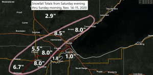
A narrow band of heavy snow impacted portions of the I35 corridor from around Mahtowa to Duluth Saturday evening into early Sunday morning with snowfall amounts ranging from 4 to 8 inches, but much lower snowfall amounts in the 1 to 2 inch range have been reported closer to Lake Superior.
Map below shows 24 hour snowfall amounts, ending 6 AM Sunday, November 15, 2020.
Source: https://lab.weathermodels.com/

Snowfall Reports from around the Northland for November 14-15, 2020
Source: https://www.weather.gov/dlh/
- Duluth Airport: 8.5″
- 1 W Esko, MN: 8.5″
- 3 N Lester Park, MN: 8.0″
- Carlton, MN: 8.0″
- 3 N Mahtowa, MN: 6.7″
- 2 NE Cloquet, MN: 5.8″
- Cloquet, MN: 5.5″
- 7 NW Two Harbors, MN: 5.1″
- 1 NNE Cloquet, MN: 4.7″
- 1 WSW Maple, WI: 4.4″
- Brule, WI: 4.0″
- Kettle River, MN: 3.8″
- 3 ENE Holyoke, MN: 3.3″
- 6 SW Finlayson, MN: 2.8″
- 1 W Solon Springs, WI: 2.4″
- Gary New Duluth, MN: 1.8″
- 3 WNW Clam Lake, WI: 1.5″
- 3 WSW Shaw, MN: 1.3″
- 2 SSW Superior, WI: 1.0″
- 2 ESE Duluth, MN: 1.0″
- Cotton, MN: 0.5″
Tim
Leave a Reply