This will be my final post in 2020, and likely will be my last post for a few days (lots of football watching ahead including the College Football Playoff games on Friday and a big NFL Sunday, plus the weather pattern locally looks pretty quiet through the weekend, perfect timing I guess)
The only issue I see weather-wise around here through Saturday could be some patchy fog at times which could lead to the development of some hoarfrost and slick spots on the roads, and like today we could even see a few fluffy snow flurries occur from time to time due to the added moisture in the atmosphere because of the patchy fog.
Happy New Year, and thank you to all who viewed Northlandweatherblog in 2020, it had 18,534 views in 2020, and 6945 visitors. A total of 352 posts in 2020. Thank you again!
The National Weather Service in Duluth, Minnesota put together a top 10 Northland Weather Events list of 2020 – Here’s the link https://www.weather.gov/dlh/2020-top-ten
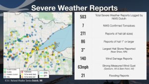
…Severe Weather Stats in the Northland for 2020…


| A warmer than average December at Duluth, Minnesota with slightly below average snowfall and precipitation. The average monthly temperature for December 2020 will finish ~5.0 degrees above normal while snowfall ends up ~1.0″ below normal, with precipitation ~0.25″ below normal. Note: I’ll have a complete climate summary for December 2020 early next week. 2020 was a warm and dry year in Duluth. The average temperature in 2020 was nearly 2.0 degrees above normal while precipitation was ~9.70″ below normal. Although not official yet, 2020 looks to rank as the 10th driest year on record, while tying for 11th warmest year on record at Duluth, Minnesota. |
| Climate Normals and Records for January at Duluth, Minnesota Normal high on the 1st: 19 degrees Normal high on the 31st: 20 degrees Normal low on the 1st: 3 degrees Normal low on the 31st: 2 degrees Averages for the month Temperature: 10.2 degrees Precipitation: 0.96″ Snowfall: 19.4″ Number of subzero nights: 15 Number of 1″ or greater snow events: 4 Number of days with snowfall 0.1″ or greater: 12 Records for the month Warmest: 23.7 degrees set in 2006 Coldest: -7.2 degrees set in 1912 Wettest: 4.70″ set in 1969 Driest: 0.13″ set in 2008 Snowiest: 46.8″ set in 1969 Least Snowiest: 2.0″ set in 1921 Astronomical Data for January Sunrise on the 1st: 7:54 AM CST Sunrise on the 31st: 7:33 AM CST Sunset on the 1st: 4:31 PM CST Sunset on the 31st: 5:10 PM CST Note: 5 PM or later sunsets return to Duluth in late January! |
Note: Duluth typically sees 15 subzero nights in January, while the average monthly temperature for January is 10.2 degrees. The outlook for January 2021 would certainly lead to fewer subzero nights compared to average, and an average monthly temperature several degrees warmer than normal. Similar to what we saw in December any arctic air masses would likely be brief if we see any at all in January 2021.
Outlook for January 2021 calls for more of the same, and that is another warmer than average month across the Northland per CFS model.
Source: https://www.tropicaltidbits.com/

Precipitation is forecast to be near normal to slightly below normal across northeast Minnesota and northwest Wisconsin in January 2021 per CFS model.
Note: Average snowfall in Duluth for January is 19.4″.

Tim
Leave a Reply