- Not expecting any major impacts from this system affecting northeast Minnesota and northwest Wisconsin tonight and Friday with generally light snowfall rates and patchy blowing snow.
- Surface temps will remain on the mild side through Friday, so it’s possible that some of the precipitation will fall as light rain or drizzle at times especially closer to Lake Superior.
- Northeast winds could gust to around 20-30 mph around Lake Superior tonight into Friday morning, with gusty winds also possible from east-central Minnesota into northwest Wisconsin.
- How crazy is this weather pattern? There’s a blizzard warning in effect for parts of western/southern Minnesota tonight and Friday, meanwhile in northern Minnesota, International Falls and Hibbing had near record warmth today.
Snowfall Reports from around the Northland for January 14, 2021 (thru 4 PM)
Source: https://www.weather.gov/dlh/
- Remer, MN: 3.5″
- Breezy Point, MN: 3.5″
- Palisade, MN: 3.5″
- Outing, MN: 3.0″
- Hinckley, MN: 3.0″
- McGregor, MN: 3.0″
- 1 ESE Nisswa, MN: 2.0″
- 8 SSW Cohasset, MN: 2.0″
- Finlayson, MN: 2.0″
- Max, MN: 1.5″
- 6 ENE Deer River, MN: 1.5″
- Deer River, MN: 1.0″
- Duluth Airport: 0.2″
- International Falls: Trace
Additional snowfall through Friday

…Local View…
- Winter Weather Advisory remains in effect through Friday afternoon for parts of north-central, east-central and northeast Minnesota, and all of northwest Wisconsin (purple area on map) Some cities included in the advisory are International Falls, Bigfork, Grand Rapids, Cass Lake, Walker, Brainerd, Hill City, McGregor, Aitkin, Pine City, Hinckley, Moose Lake, Cloquet, Duluth, Superior, Solon Springs, Washburn, Bayfield, Ashland, Hurley, Gile, Danbury, Siren, Minong, Spooner, Shell Lake, Hayward and Winter.
- Plan on slippery road conditions. Snow/slush covered roads will impact the Friday morning commute.
Source: https://www.weather.gov/dlh/

Looking at limited (light blue) to minor (yellow) impacts from snow across the Northland tonight and Friday, while moderate to major impacts are expected due to snow, blowing snow and blizzard conditions in southern Minnesota and parts of Iowa through Friday.
Source: https://www.wpc.ncep.noaa.gov/

…Regional View…
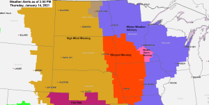
It’s a colorful warnings map today!
Blizzard Warning (red)
Winter Storm Warning (pink)
Winter Weather Advisory (purple)
High Wind Warning (brown)
Red Flag Warning for extreme fire weather danger (purple)

A large low pressure system won’t be moving a whole lot tonight with bands of moisture continuing to advect from SE to NW on the north/east side of this low pressure system (green arrows) while drier air wraps up from the south (orange arrow on map)
Water vapor loop from around Noon to 4 PM CT Thursday, January 14, 2021.
Source: https://weather.cod.edu/

Snow has been lifting slowly northwest while inching north this afternoon – Radar loop from ~7 AM to ~4:30 PM Thursday, January 14, 2021.
Source: https://weather.cod.edu/

The Northland will continue to see some snow or a mix of precipitation at times through Friday, but precipitation should begin to taper off from NW-SE by Friday afternoon, except in northwest Wisconsin and along the South Shore where some snow could linger into Friday night.
18z RGEM model simulated radar forecast through 6 AM Saturday.
Source: https://www.tropicaltidbits.com/

Low pressure over central Minnesota as of 3 PM Thursday will drop SE into eastern Iowa by Friday morning, then will see this low move or redevelop NE into lower Michigan by Friday evening.
A tight pressure gradient covered the Plains today between the low to the east and strong high pressure over the Northern Rockies, this has resulted in a very windy day from the Dakotas to Kansas.

A plume of moist air continues to pump NW into the upper Midwest today while drier air pushes SE out of the Dakotas.

…High Wind…
Strong northwest winds occurring today across the Northern and Central Plains with 850mb winds >50 knots! The strong winds associated with this storm won’t be affecting the Northland as they remain further to our west and south through Friday.

A fairly amplified weather pattern in place today with an upper level ridge (blue H on map) poking north into the western US with another ridge covering the eastern Great Lakes and adjacent portions of eastern Ontario. Upper level troughs (red L on map) were found across the Northern Plains and south of Alaska.

Road Conditions
Minnesota: https://511mn.org/
Wisconsin: https://511wi.gov/
Tim
Leave a Reply