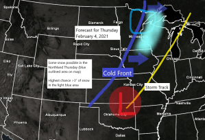
Snow chances return to northeast Minnesota and northwest Wisconsin on Thursday, and there is even a chance for some patchy freezing rain/freezing drizzle in parts of the area before precipitation goes over to snow. Note: Another thing to keep an eye on is the potential for a ‘flash freeze’ in the Northland on Thursday since temperatures look fairly mild prior to Noon, with falling temps during the afternoon hours, and if the cold air rushes in quickly, this could result in a flash freeze in parts of the area.
At the moment this doesn’t look like it will be a major storm for the Northland, but this system has a chance to produce a more significant snowfall in parts of the area (4-6″+ amounts) if the trough (black line on map) approaching from the west can slow down prior to it moving through the Northland, similar to what the animation below is showing which has support from the UK model and to some extent the GFS model, but the majority of the computer models continue to show the trough remaining rather progressive until it gets east of our area, and the end result from that would be for mostly a dusting to an inch or two of snow in northeast Minnesota and northwest Wisconsin on Thursday. Stay tuned.
Source: 18z RGEM model 2.1.21; 500mb forecast valid 6 PM Wednesday to Midnight Friday; https://www.tropicaltidbits.com/

The next few days will remain relatively mild across the Northland, but big changes are coming late this week into early next week as cold arctic air (blue and purple colors on animation below) heads south/east covering a large area of the Northern Rockies, upper Midwest, Plains and Great Lakes.
Note: High temperatures are forecast to only be in the single digits and teens below zero across the Northland Saturday, Sunday and Monday with overnight lows in the teens, 20s and 30s below, with even a few -40s possible in the typical cold spots come Sunday morning and Monday morning.
Temperature anomaly forecast valid from February 4-10, 2021 per 2.1.21 12z European ensemble model.
Source: https://weathermodels.com/

Upper level ridges (blue H on map below) west of California and NE of Hudson Bay Canada will help steer a lobe of the Polar Vortex/upper level low (red L on map) SE toward the upper Midwest and Great Lakes this weekend with very low 500mb heights, around -2 to -3 sigma compared to normal.
Source: 18z GFS model 1.31.21 – 500mb height anomaly forecast valid February 5-7, 2021; https://weather.cod.edu/

A prolonged period of dangerously cold wind chills are likely starting either Friday or Saturday, and then continuing into early next week.
Wind chill temperatures in the -20s and -30s are likely this weekend into early next week, with some -40s possible especially Sunday morning and Monday morning. Wind chill headlines (advisories and warnings) will likely be needed this weekend into early next week.
Source: 12z European computer model 2.1.21; https://www.pivotalweather.com/

Tim
Leave a Reply