The big story going forward is what happens to the ongoing and expanding drought across the upper Midwest? A lot of uncertainty here, but basically there’s two options, either a wet weather pattern locks in for weeks or months to erase this ongoing, slowly worsening drought, or we stay very dry, with only the occasional precipitation event, the latter is what we’ve been seeing more or less of across the Northland for about a year now, with only a few changes mixed in in the overall weather pattern, one that comes to mind was last July where Duluth saw a couple of significant rain events.
Not only are there drought concerns in the Northland, but the risk for wildfires could also begin to increase over the next few weeks/months as we continue to lose the snow pack from this winter, and while we await the spring green-up which is still at least a month or two away around here.
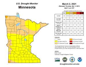
Drought conditions continue to expand across Minnesota, here’s the latest drought monitor as of March 2, 2021.
- All of Minnesota is Abnormally Dry
- Nearly 40% of Minnesota is in Moderate Drought (D1)
- Less than 1% of Minnesota is in Severe Drought (D2)
Note: Three months ago, only 10% of Minnesota was in Moderate Drought compared to nearly 40% here in early March.

No big changes in this week’s drought monitor for Wisconsin, with 60% of the state Abnormally Dry.

Much of the High Plains continue to be affected by moderate, severe, extreme and even exceptional drought conditions as of March 2, 2021.
North Dakota: Around 92% of the state is in Moderate Drought, and nearly 69% of the state is in Severe Drought.
South Dakota: Moderate Drought covers 89% of the state, while 49% of the state is in Severe Drought, while a small part southeast South Dakota (Sioux Falls area) is in Extreme Drought.

The chances for a stormier weather pattern that would stick around a while looks pretty low across the Northland through mid month, with precipitation totals for the next two weeks generally below normal across most of northeast Minnesota and northwest Wisconsin per Euro ensemble guidance.

Goes-16 Day Cloud Phase Satellite loop from today, Thursday, March 4, 2021 showing the remaining areas of snow cover (green). Will continue to see the snow cover shrink into early next week, in fact there might not be a whole lot of snow left on the ground in most of Minnesota by the middle of next week, especially if we get some rain to accompany the warmer temps early next week.

Widespread 60s this afternoon from western North Dakota south through the Central Plains, with even some 70s in parts of Kansas this afternoon, but temperatures are a lot cooler around Lake Superior this afternoon due to an east-northeast wind which is helping to keep temperatures close to the freezing mark, but that’s actually pretty close to what our normal highs are in early March.

- Cooler by the lake will be a common theme through at least Saturday with daytime highs in the 30s and a northeast wind near Lake Superior, while farther inland highs will range from the upper 30s to upper 40s for Friday and Saturday.
- Highs near 50, or into the 50s are possible in much of northeast Minnesota and northwest Wisconsin from Sunday through Tuesday, but temperatures could remain a lot cooler near Lake Superior especially on Sunday.
- Our next best chance for getting some precipitation around here comes in the Tuesday-Thursday, March 9-11 time frame. And most of this precip looks to be in the form of rain the way it looks now.
Eventually will see that ridge over the High Plains shift east over the upper Midwest and Great Lakes by early next week, some of the warmest temperatures through early next week will be found near and underneath that ridge.

Probabilities for high temperatures of 50 degrees or warmer remain highest west and south of the Northland through Saturday, but this changes early next week, with higher probabilities for 50s in much of the Northland, especially in the Monday and Tuesday (March 8-9) time frame per European ensemble guidance.
Note: The average date for the first 50 degree temperature in Duluth is March 20th, last year’s first 50 came on March 8th, and this year’s first 50 may come about the same time.

European model shows enough CAPE (instability) developing in much of Minnesota for an isolated thunder threat for next Wednesday, March 10.
The threat for isolated thunderstorms would start in west-central portions of the state early Wednesday morning, then could shift farther east into central, eastern and southern Minnesota and western Wisconsin for Wednesday afternoon and evening. Note: The GFS model shows very little instability, and no thunderstorms for the middle of next week, so will see how the models trend in coming days on this threat.

Thanks for reading and or checking out the podcast version of this post
Leave a Reply