A very nice late winter/early spring day across the Northland as high temperatures climbed into the mid 40s to around 50 degrees in northwest Wisconsin, and in the low to upper 50s across much of north-central and east-central Minnesota.
Look at those 60s this afternoon in parts of western and southern Minnesota, those same areas could see highs in the 70s on Tuesday.
Note: Temperatures remained a lot cooler today near Lake Superior (35 to 40 degrees), but that’s not a surprise since winds were out of the east. It does look like will get a wind shift (offshore direction) on Monday, and that should lead to highs getting into the low 50s in Duluth and Superior, even near Lake Superior.
Assuming the Duluth Airport hits 50 on Monday, March 8th, it’ll be the first 50 this year, and the first since November 9th, 2020 (high of 65 degrees) The average date for the first 50 in Duluth is March 20th, while last year’s first 50 came on March 8th.

Upper level ridge (blue H on map) which brought the very mild temperatures to the upper Midwest is moving off to the east late this afternoon, but ridging will move back into the upper Midwest for Monday and Tuesday before we see a change in the pattern for midweek as a trough approaches from the west and south.

Look at these forecast temperatures for Tuesday afternoon per 18z RGEM model.
*Near 80 degree temps possible as far north as southeast South Dakota.
*70s in western/southwest Minnesota.
*50s and 60s in northeast Minnesota and northwest Wisconsin, but much cooler near Lake Superior as east winds return on Tuesday.

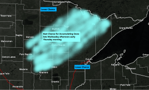
…Midweek System…
- An area of low pressure is forecast to move northeast out of the Central Plains on Wednesday, but the storm track is still uncertain, with it ranging from as far west as central Minnesota, to as far east as east-central Wisconsin.
- Enough cold air looks to wrap into the backside of this system to produce a narrow band of accumulating snow somewhere across western, central or northeast Minnesota from late Wednesday afternoon into Thursday morning.
- Looks like most of the precipitation in northwest Wisconsin will fall as rain, but if the storm track shifts more to the south/east, then even parts of northwest Wisconsin could see accumulating snow, while chances would then diminish across northern Minnesota.
- Rain and snow is possible in Duluth and Superior for midweek, with rain most likely Wednesday afternoon, followed by a rain/snow mix or a changeover to all snow for Wednesday night. At the moment it looks like the greatest chance for accumulating snow would be west/north of the Twin Ports, but this could certainly change in the next few days depending on the storm track.
- A few thunderstorms are even possible on Wednesday across parts of the upper Midwest.

Tim
Leave a Reply