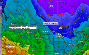
A northwest flow aloft will remain in place across the Northland through this weekend as an upper level low moves slowly E-SE across central Canada. This NW flow will keep temperatures on the cool side (but not terribly cold) but it will also keep our area pretty dry. We’re looking at daytime highs ranging from around 45 to 57 degrees in northeast Minnesota and northwest Wisconsin from Wednesday through Sunday, May 5th through May 9th, normal highs across the Northland during the aforementioned time period are generally in the low to mid 60s.
Nothing too exciting when it comes to the weather in the Northland at least through early next week with no widespread or significant rain events, and certainly no outbreaks of thunderstorms/severe weather around here at least through early next week, but there are some signs showing up in model guidance for the pattern to turn a little more active during the second half of May, but time will tell if that will verify or not.
MRMS radar loop ending 5:10 PM Tuesday, May 4, 2021.

- Isolated showers (black outlined area on image above) will continue to move SE through parts of the Northland this evening followed by mainly dry conditions overnight and through the day Wednesday.
- Scattered shower chances will return to the Northland Thursday as a cold front makes its way through the area (see radar forecast below).
- Mainly dry Friday through Sunday.
18z NAM 3km model simulated radar forecast valid from 7 AM Thursday to 7 PM Thursday, May 6, 2021.

Much of the U.S. is on the ‘cool’ side for early May standards with some exceptions, one being across parts of the southwest U.S., and the other near the Gulf coast and into the Mid-Atlantic where it’s a lot warmer!

Tim
Leave a Reply