Rainfall deficits for July 2021 (thru 4 PM on the 20th)
Duluth, MN: -2.44″ below normal
International Falls, MN: -2.29″ below normal
Hibbing, MN: -2.15″ below normal
Ashland, WI: -2.09″ below normal
Brainerd, MN: -2.04″ below normal
Note: Duluth is running -5.04″ below normal in rainfall since June 1st, while International Falls is running -4.36″ below normal in rainfall.
Year to Date precipitation deficits include -6.26″ below normal at International Falls, and -5.79″ below normal at Duluth, but if you go all the way back to January 1, 2020 (which is what I like to do since this current drought goes back a year) then Duluth is closing in on -16″ below normal in precipitation (-15.71″ below normal from 1/1/20 to 7/20/21)
- July 6 – The last time the Duluth Airport picked up at least a quarter inch of rain (2 weeks ago)
- June 29 – The last time the Duluth Airport recorded a thunderstorm (closing in on a month ago)
- 13 days at or above 80 so far this month at Duluth – Average number of 80 degree days in July is 11 (record is 25 days at or above 80 set in July 2012)
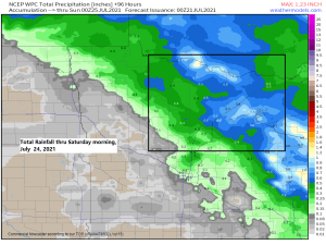
Chances for a few showers and thunderstorms continue in northeast Minnesota and northwest Wisconsin over the next few days, but this won’t be a widespread rain, so some areas will likely miss out or not get a whole lot of rain through Saturday morning. Severe weather is not expected through Thursday, but there is some risk for a few strong to possibly severe thunderstorms in parts of the area Friday or Friday night, this is when we could see things come together at least to some extent to produce a few stronger storms…Time will tell.
As for rainfall totals over the next few days, well there is a chance that much of the Northland will pick up at least a tenth of an inch of rain (not a whole lot) but some of us will likely receive more than that, possibly upwards of a half inch to an inch of rain through Saturday morning, but those chances at least right now look greatest across far northeast Minnesota (Arrowhead region) into northern Wisconsin.
Here’s the 18z HRRR model simulated radar forecast valid 7 PM Tuesday to 7 AM Thursday.

An Air Quality Alert is in effect until 6 AM Thursday, July 22, 2021 for the area shaded in orange which is pretty much all of Minnesota.

Wildfire smoke will remain over the Northland at least through Thursday, although conditions might improve a bit by then compared to what we’re seeing today.
A lot of this smoke will remain aloft creating more hazy/milky looking skies, but will also continue to see this smoke mix down to the surface at times in parts of the Northland through Thursday morning.

Smoke has been so thick today its been reducing the visibility to around a mile or so in parts of the Northland.
Visibilities as of 4 PM Tuesday, July 20, 2021
Brainerd, MN: 0.75 miles
Longville, MN: 1 mile
Pine River, MN: 1.25 miles
Grand Rapids, MN: 1.5 miles
Aitkin, MN: 2 miles
Chisholm-Hibbing Airport: 2.5 miles
Hinckley, MN: 3 miles
Siren, WI: 4 miles
Cloquet, MN: 5 miles
Duluth Airport: 6 miles
This is about the worse air quality conditions I’ve seen before in Minnesota.
Brainerd had an AQI of 305 at 3 PM today which is considered hazardous (health warning) while other cities in northwest and north-central Minnesota were in the very unhealthy category (health alert) All this is a result of thick wildfire smoke moving over Minnesota today, and a lot of this smoke has been mixing down to the surface creating very poor air quality in parts of the state.


The pattern we’re seeing today won’t be changing much the next few days.
Core of the heat associated with an upper level ridge will remain west and southwest of the Northland at least through Thursday, but there continue to be indications showing up in model guidance for some heat to build NE into the Northland this weekend into next week, but how warm TBD…

Temperatures are running 15 to 25 degrees cooler this afternoon compared to Monday afternoon near Lake Superior as the air conditioning machine has been activated.

High temperature forecast valid from Wednesday, July 21, 2021 to Sunday, July 25, 2021.
60s and 70s continue near Lake Superior for Wednesday and Thursday, with 70s and 80s farther inland in northeast Minnesota and northwest Wisconsin, while 90s will be common in much of western, central and southern Minnesota.
This weekend looks pretty warm as temps climb well into the 80s to lower 90s across the Northland.

Tim
Leave a Reply