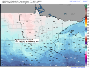
Dry and mild in the Northland on Saturday with highs in the 30s to lower 40s which is roughly 5 degrees warmer than normal for November 20th.
Colder temperatures along with gusty winds return on Sunday with highs only in the 20s and 30s. A burst of snow is also likely spreading NW-SE across the Northland Sunday morning, but this snow won’t last very long, maybe an hour or two at most in any given location. Total snowfall accumulations on Sunday will generally be <1″, but the exception to this might be along the Minnesota-Ontario border where up to 2″ of snow may accumulate.
For Duluth and Superior — Some snow is possible on Sunday from ~7 AM to 10 AM so the timing has changed a bit compared to 24 hours ago, in that things have sped up just a bit. A few lingering snow showers and flurries will be possible Sunday afternoon. Total snow accumulations <1″.
12z European model simulated radar forecast valid from Midnight Sunday to Midnight Monday (snow in blue colors).

It will be windy on Sunday due to a strong cold air advection pattern.
Winds will shift to the northwest Sunday with gusts of 20 to 30 mph, possibly stronger.
18z NAM 3km model wind gust forecast valid 6 AM Sunday to Midnight Monday.

Temperatures are still in the single digits and teens below zero in much of Alaska and northwest Canada late this afternoon. A chunk of this arctic air will break off while spreading east-southeast across parts of Canada and into the Northland for Sunday and Monday, but this air mass will modify quite a bit by the time it reaches our area early next week, in other words we’re not looking at widespread subzero temps in the Northland early next week.
Note: Milder temps look to return next Tuesday and Wednesday, but another quick shot of cold air is possible for Thanksgiving, but no signs of any major storm affecting the Northland through next week.

Looking ahead to the rest of November shows very little additional snow in the Northland per ensemble model guidance, with amounts in both the EPS and GEFS models generally in that 1 to 4 inch range in northeast Minnesota and northwest Wisconsin, with the highest amounts generally in far northern Minnesota.
12z EPS model total snowfall thru November 30, 2021.

12z GEFS model total snowfall thru November 30, 2021.

Going one step further here — Only 5/20 or 25% of GEFS ensemble members show 2″ or more of snow in Duluth thru November 30th.
Blue colors on the images below represent snowfall of 2″ or more.

Tim
Leave a Reply