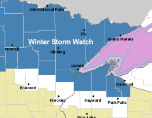
Winter Storm Watch (blue area on map) in effect from Saturday night through Sunday night for much of northern and northeastern Minnesota and parts of northwest Wisconsin.
Some cities included in the watch are International Falls, Bigfork, Grand Rapids, Cass Lake, Walker, Hill City, Moose Lake, Cloquet, Duluth, Hibbing, Cook, Crane Lake, Orr, Ely, Two Harbors, Isabella, Silver Bay, Grand Marais, Superior, Solon Springs, Washburn, Bayfield, Ashland and Hurley.
Snowfall accumulations of 6 or more inches are possible in the watch area.
Travel could be very difficult.
Blowing and drifting snow is also possible especially along the North Shore of Lake Superior on Sunday.
Accumulating snow is likely in all of northeast Minnesota and northwest Wisconsin from Saturday night through Sunday night, but there continues to be some uncertainty in model guidance regarding the storm track and where the most precipitation/snowfall will occur.
Overnight model data is split, with the NAM and Euro models favoring more northern Minnesota and the Arrowhead for greatest snow amounts this weekend with lesser amounts of snow farther south including for Duluth and northwest Wisconsin, while the GFS and Canadian models dig the system further south, which shifts the highest snow amounts farther south to include Duluth and northwest Wisconsin with lesser amounts of snow in far northern Minnesota.
Wherever that main band of snow sets up, the potential is there for snow totals to reach 6 or more inches.

Tim
Leave a Reply