5:41 PM Saturday, December 4, 2021
There has been a slight southward shift in model guidance today in regard to where the main snow band sets up and the storm track for Sunday.
Snowfall totals will likely drop off quite a bit on the far north and far south edges of where the main snow band is on Sunday.
Blizzard conditions are expected Sunday into Sunday night along portions of the North Shore of Lake Superior including for the cities of Tofte, Lutsen, Grand Marais, Hovland and Grand Portage, this would also impact Highway 61 from Taconite Harbor to Tofte to Lutsen to Grand Marais to Hovland to Grand Portage.

Here’s my updated snowfall forecast as of late Saturday afternoon but keep in mind that a few more changes are not out of the question over the next 12 hours or so.
*I’ve increased snow totals for the Twin Ports with 6 to 9″ of snow possible, with 9-11″ snow totals just north of Duluth, so if this system shifts just a little more south, that will also shift that 9-11″ zone a little further south.
*11 to 18″ of snow for much of the North Shore due to lake and terrain enhanced snow which is likely during the day Sunday.
*Lowered snow amounts a bit near the Borderland including for the International Falls area (4-6″).
*Other changes were to increase snow totals for much of east-central Minnesota including the Brainerd Lakes area and I also increased snow totals for much of northwest Wisconsin.

Snow is expected to overspread the Northland from SW-NE late this evening through daybreak Sunday with snow continuing all day Sunday into Sunday evening before tapering off from NW-SE early Monday morning.
For Duluth and Superior: Snow starts early Sunday morning ~1 AM to 3 AM. Snow ends early Monday morning ~1 AM to 3 AM. Periods of moderate to heavy snow is possible during the day Sunday with gusty ESE winds of 15 to 25 mph. Winds shift to the NW Sunday night with wind gusts of 20 to 40 mph possible late Sunday night into early Monday morning. Patchy blowing snow is likely Sunday into early Monday morning.
Note, there is a chance that southern portions of the Northland including eastern Minnesota and parts of northwest Wisconsin will be impacted by a dry slot for a time Sunday afternoon which may lead to a decrease in snowfall intensities as well as introducing a risk for some patchy freezing drizzle. This dry slot is forecast to remain just south of the Twin Ports the way it looks now but it’s a close call!

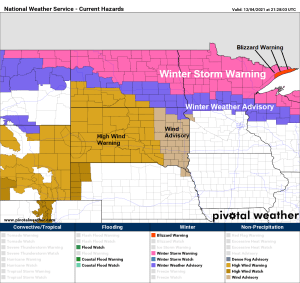
NWS alerts map as of 4 PM Saturday, December 4, 2021
Red: Blizzard Warning
Pink: Winter Storm Warning
Purple: Winter Weather Advisory
Travel could be very difficult in much of the Northland Sunday into early Monday morning.
Expect snow covered and slippery roads, and reduced visibilities due to falling snow and patchy blowing snow.

Winter Storm Severity Index valid for Sunday into early Monday.
Moderate Potential Winter Storm Impacts covers pretty much all of northern Minnesota with Major Potential Winter Storm Impacts for portions of the North Shore and Arrowhead (red area on map). Much of eastern Minnesota and northwest Wisconsin are in Minor Potential Winter Storm Impacts.

Areas in red and purple on the map below have the greatest chance for exceeding warning criteria snowfall ending 6 AM Monday.

Forecast storm track through Monday morning is from central Montana to along the North Dakota-South Dakota border to central Minnesota then across south-central portions of Lake Superior.

One thing which is fueling our winter storm this weekend is this major temperature contrast where we have temperatures this afternoon that are close to -50 F in eastern Alaska, while temperatures are in the middle 60s in parts of Colorado including at Denver.

Powerful jet stream remained centered across the northern U.S. today with wind speeds >120 knots so our approaching winter storm has a lot of upper-level support.

An area of strong warm air advection (red colors) will lift NE into our area late tonight and Sunday which will help produce bands of heavy snow in the Northland.

So, with such strong warm air advection and with a very strong jet stream over the area, we should see areas of robust lift pass through northeast Minnesota and northwest Wisconsin on Sunday indicated by the yellow, orange and red colors on the animation below. What this means is that we should see bands of very heavy snowfall move through parts of the area on Sunday with snowfall rates of 1″ or more/hour.

…Arctic Blast Monday and Tuesday…
First the snow then comes the cold!
Temperatures are going to tumble big time on Monday, going from the 20s at around Midnight Monday, down to the single digits and teens below zero by mid-morning Monday.

Widespread wind gusts of 20 to 30 mph are expected in the Northland from Sunday into Monday morning, with wind gusts of 40 to 50 mph or greater possible especially along the North Shore of Lake Superior.
Winds will be out of the east or southeast on Sunday shifting to the northwest late Sunday night.
The HRRR model is picking up on the potential for gravity wave development and or Katabatic wind event along the North Shore of Lake Superior early Monday morning, and if this does occur, and depending on the strength of it, we may see a period of very strong wind gusts develop early Monday morning along the North Shore of Lake Superior with the possibility of wind gusts >50 mph.

Tim
Leave a Reply