A powerful storm will impact the upper Midwest from late Wednesday into early Thursday.
This storm will bring a variety of hazards to the Northland, including rain, fog, snow, falling temperatures, possible flash freeze, thunderstorms, high winds and possible power outages.
I’ll break down each one of these hazards in this post.
…High Wind Potential…
Wind gusts of 50 to 60 mph are possible over much of the Northland Wednesday evening into Thursday morning, with a chance for even stronger wind gusts (>60 mph) in a few locations in the Northland.
But expanding out a bit shows widespread high winds across the region, with wind gusts of 70 to over 80 mph possible over parts of southern Minnesota into parts of Wisconsin during the Wednesday evening to Thursday morning time frame.

There looks to be two rounds of high wind potential with this powerful storm.
The first would be associated with a line of thunderstorms which moves quickly NE while impacting much of southern and parts of eastern Minnesota into much of Wisconsin, this would roughly be in that 6 PM to 10 PM Wednesday time frame.
The second round of high wind potential would be more widespread and be caused by strong cold air advection and a rapidly deepening surface low lifting NE out of southwestern Minnesota. This would spread SW to NE beginning mid to late evening on Wednesday, and then persisting into Thursday morning.
The possibility exists for there to be widespread power outages due to the high winds across the upper Midwest late Wednesday into Thursday.

Wind alerts are widespread from the Central Plains to the Great Lakes Wednesday into Thursday, and we may even see these expand a little more to the north to include parts of northern Minnesota.

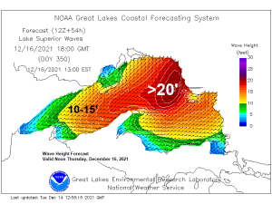
…Storm Watch for parts of Lake Superior…
We may see hurricane force winds develop over parts of Lake Superior and over the Keweenaw Peninsula in upper Michigan Thursday morning.

Very large waves are forecast to develop over Lake Superior on Thursday with potential for waves >20 feet developing over eastern Lake Superior.

…Severe Weather Potential…
Scattered to isolated strong to severe thunderstorms are possible late Wednesday afternoon and Wednesday evening from north-central Iowa to south-central Minnesota into west-central Wisconsin.
A few non-severe thunderstorms are possible in the Northland Wednesday evening, mainly from east-central Minnesota into all of northwest Wisconsin, but at the moment the potential for severe thunderstorms is greatest a little farther south, but this may change in future forecasts on Wednesday.

There is a chance for isolated tornadoes across southern Minnesota, central/northern Iowa into west-central Wisconsin from late Wednesday afternoon into Wednesday evening.

How rare is it for there to be a risk for tornadoes in Minnesota in December?
If we do get a tornado somewhere in the 5% (brown area) tornado risk area on Wednesday it would be the first tornado to occur in that area in the month of December dating back to 1950. Credit Joel Kirschenman
-Since 1986, there’s only been 1 severe thunderstorm warning in Minnesota in the month of December.
-Since 1986, there has never been a tornado warning issued in Minnesota in the November through February period. The latest confirmed tornado in Minnesota was on November 16, 1968. Credit Kevin Mahoney; MNDNR

…Timing of the precipitation…
- Areas of drizzle and fog are possible late tonight through the day Wednesday, and we may even see a few measurable rain showers as well on Wednesday. Some of the fog that develops could become dense late tonight and Wednesday.
- Rain coverage and intensity ramps up late Wednesday afternoon through Wednesday evening, and this is also when we could get a few thunderstorms in parts of the Northland. Note: Rain chances increase in Duluth especially after 5 PM Wednesday.
- Rain changes to a period of snow early Thursday morning from west to east across the Northland.
- The changeover from rain to snow occurs first over western areas after Midnight Thursday, then reaches Duluth ~2 AM to 4 AM Thursday.
- Snow ends from SW-NE before Noon Thursday.
18z NAM 3km model simulated radar forecast valid Midnight tonight to Noon Thursday.
Rain in green
Snow in blue

…Snowfall Forecast…
Here’s my snowfall forecast for Thursday morning.
Snow amounts may increase or decrease depending on how quickly rain turns to snow, and once that happens how long it snows for.
And the snowfall gradients may also shift around a bit over the next 12-18 hours.
At the moment this looks like a quick hitting snowfall, with most of it occurring in the Midnight to 6 AM Thursday time frame.
Note: Even a half inch to an inch of snow with this type of storm could create dangerous road conditions due to the rapid drop in temperature, high winds and the rain that falls prior to the cold air and changeover to snow. It’s possible that some parts of the Northland will see a flash freeze occur early Thursday morning.

A widespread half inch or more of precipitation is forecast to fall in northeast Minnesota and northwest Wisconsin Wednesday into early Thursday.

…Synoptics of this storm…
Intense lift will spread quickly NE across the upper Midwest Wednesday night represented by the red and darker red colors on the animation below.

One can also use the 500mb plot to determine how much lift a storm will have, and well this one for Wednesday night looks to have tremendous amounts of lift which leads to the potential for heavy precipitation rates and some thunderstorms.

Just a tremendous amount of wind energy expected with this storm.
A low-level jet cranking to nearly 90 knots early Wednesday evening over Iowa, this leads to a rapid surge of warm air and moisture advection while also advecting higher amounts of instability N-NE into the upper Midwest.

850mb winds are forecast to be +1 to +3 sigma above normal from the Plains to Great Lakes late Wednesday into early Thursday, so it is unusual to have such strong low-level winds in these areas in mid-December.

Mid-level winds also look incredibly strong with >100 knot winds expected over Iowa early Wednesday evening.

…Temperature drop…
One of the bigger issues with this storm will be the rapid drop in temperatures.
Temperatures in the 40s and 50s in the Northland Wednesday evening are expected to fall to the teens and 20s Thursday morning.
Temperatures in the mid to upper 40s in Duluth at Midnight Thursday falling to the lower 20s around 6 AM Thursday and to the mid to upper teens by mid to late morning on Thursday.

This temperature contrast on Wednesday is something else!
Temperatures at 850mb (~5000 feet) are forecast to be in the +10 to +17C range across much of Minnesota and Wisconsin, these kinds of temperatures are more typical of late spring or early summer! Meanwhile you have arctic air sitting over Saskatchewan where 850mb temps are forecast to be at around -24C on Wednesday.

…Storm Track and Central Pressure…
-Low pressure is forecast to be over southern Wyoming at 6 AM Wednesday, this low is then forecast to move into northwest Iowa around 6 PM Wednesday, and is forecast to be centered just northwest of Lake Superior by 6 AM Thursday.
The central pressure of the low is expected to fall from ~993mb Wednesday morning to ~974mb by Thursday morning, with most of its deepening occurring as it lifts NE across Minnesota Wednesday night.

Tim
Leave a Reply