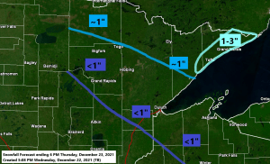
A weak system may bring a little snow (inch or less of accumulation) to parts of the Northland late tonight and on Thursday, but the only area that may see more than an inch of snow (1-3″ range) looks to be in the Arrowhead from northeast of Silver Bay to Grand Marais to Hovland to Grand Portage.
Another fast-moving system may affect parts of the Northland on Christmas Eve, but a lot of warm air will accompany this system, so any precipitation that falls could take the form of snow, rain or patchy freezing rain, but anything that does fall looks pretty light at the moment, with precipitation chances highest prior to Noon on Friday.
Another system may impact the Northland Christmas Day, and with colder air in place, any precipitation that falls should be in the form of snow, but nothing significant in terms of snow accumulation is expected at this time for Christmas Day.
Here’s the NAM 3km model simulated radar forecast valid Midnight Thursday to Noon Friday.
Snow in blue
Mixed precipitation in pink
Rain in green

LOTS OF POTENTIAL FOR A STRETCH OF SNOWY WEATHER LATE THIS WEEKEND INTO NEXT WEEK
There’s been very little change in the models in regard to the pattern for this weekend into next week. It’s a pattern that may become very active with multiple low-pressure systems moving ENE out of the western U.S. where a deep trough will reside.
-How strong each of these systems are will determine how heavy the precipitation will be.
-Storm tracks and temperatures will determine where the rain/snow line sets up.
Computer models have been and will continue to struggle with this pattern until the event gets closer.
At the moment the time periods where we may see accumulating snow (possibly significant amounts) in the Northland are
~December 26-27
~December 28-29
~December 30-January 1
European computer model 500mb forecast valid December 25, 2021, to January 1, 2022

Although brief shots of cold (possibly arctic air) may spill as far east as the Northland at times next week, the arctic air should be more intense and much more persistent farther to our west, from western Canada into the Northern Rockies and Northern Plains next week.
European computer model temperature anomaly forecast valid December 25, 2021, to January 1, 2022.
Arctic air (below normal temps) in green, darker blue and purple colors on the animation below
Warmer air (above normal temps) in orange, red and white colors on the animation below

BRIEF ARCTIC BLAST THIS MORNING
Low temperature reports from Wednesday morning, December 22, 2021
2 E Celina, MN: -18 F
Cook, MN: -15 F
Longville, MN: -15 F
Hibbing, MN: -14 F
Cotton, MN: -14 F
3 E Orr, MN: -14 F
International Falls, MN: -13 F
Eveleth, MN: -13 F
Moose Lake, MN: -13 F
4 W Clam Lake, WI: -13 F
Northome, MN: -12 F
Embarrass, MN: -12 F
Bigfork, MN: -11 F
Siren, WI: -10 F
Spooner, WI: -10 F
Hayward, WI: -9 F
Hinckley, MN: 9 F
Cloquet, MN: -9 F
Solon Springs, WI: -9 F
Brainerd, MN: – 8 F
Orr, MN: -8 F
Duluth, MN (Airport) -7 F
Walker, MN: -7 F
Butternut, WI: -7 F
Duluth Sky Harbor Airport: -2 F
Superior Airport: -2 F
Ashland, WI: -1 F
WARMING UP THURSDAY AND FRIDAY FOLLOWED BY A COOLING TREND THIS WEEKEND
Warmer temperatures will be returning to the Northland over the next few days with Friday looking like the warmest of the next three days.
High temperature forecast for northeast Minnesota and northwest Wisconsin
Thursday 12/23: Middle 20s to lower 30s.
Christmas Eve 12/24: Middle 30s to around 40.
Christmas Day 12/25: Teens in northern Minnesota. 20s to lower 30s in eastern Minnesota and northwest Wisconsin.

Christmas is looking very warm across the southern U.S. into parts of the Midwest and Ohio Valley, in fact record high temperatures are likely Friday through Sunday especially across the southern U.S. Meanwhile arctic air will continue to build across the Northern Rockies this weekend into next week.

Tim
Leave a Reply