4:49 PM Monday, January 10, 2022
My site, Northland Weather Blog has passed 50,000 all-time views as of January 10, 2022, just wanted to say thank you to those who have checked out my blog in the past, and to those who continue to do so today, I appreciate it! I started blogging back in 2009 using E-Blogger, back then my blog was called Tim’s Weather Blog, but I moved everything over to WordPress in July of 2019 and also changed the name of my blog to Northland Weather Blog, but okay enough of that, let’s get to the weather!

Tonight, is likely to be our last subzero night at least until this weekend.
It’ll be another chilly one tonight with lows in the single digits below to around 20 below zero, but temperatures may actually rise a bit after Midnight, so the coldest temperatures are expected to occur prior to Midnight tonight.
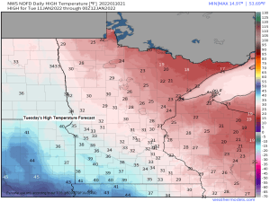
Highs in the Northland on Tuesday are forecast to be mainly in the 20s which is near normal to as much as +10 degrees above normal for January 11th.

A SNOWIER PATTERN AHEAD?
The pattern ahead might turn a little snowy once again with an active clipper pattern possibly setting up across the Northern Plains and upper Midwest starting later this week and continuing into the foreseeable future.
Although chances we’re hit by a powerful winter storm are on the low side over the next two weeks given the expected pattern, there may be several snow events (mostly light amounts) on the way through January 26.
Here’s the GEFS model snowfall accumulation forecast thru January 26, 2022, with the purple colors representing snowfall amounts of 6″ or more.
13/20 (65%) GEFS members show 6″ or more of snow in Duluth by January 26, 2022.

A clipper system late this week may bring some accumulating snow to parts of the Northland, although at the moment those chances look highest across western/southern Minnesota, possibly extending as far east as the Brainerd Lakes and Twin Ports area, while northern Minnesota and the Arrowhead have a lesser chance for accumulating snow late this week. Stay tuned.
There is also a chance we see another clipper prior to Friday’s system (sometime in the Tuesday night to Thursday time frame), but the track and timing of that one is all over the board today.

500mb forecast valid January 13-17, 2022 — More or less a NW flow for the upper Midwest which means no Gulf of Mexico moisture connection with any system coming out of western Canada, so heavy snowfall amounts are unlikely to occur with any system that impacts the Northland into at least early next week.
Also, there continues to be signs will see the Polar Vortex drop south to Hudson Bay or near Hudson Bay Canada later this week into next week, with shots of cold arctic air possibly returning to the Northland by next week.

Tim
Leave a Reply