5:13 PM Saturday, January 15, 2022
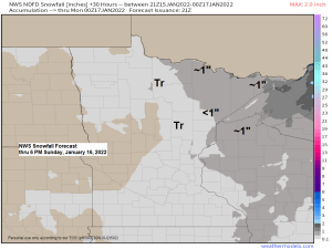
A little bit of snow is on the way for late tonight into Sunday morning, with lingering flurries and snow showers possible Sunday afternoon.
Snowfall amounts with this system should remain on the light side with accumulations of mostly under an inch expected in the Northland, but a few locations up near the Ontario border and in the Arrowhead may see upwards of 1-2″ of snow by Sunday afternoon.
For Duluth — Some snow is possible Sunday morning (~4 AM to 8 AM) with a chance for a few snow showers and flurries for Sunday afternoon. Total snowfall accumulations <1″.
18z NAM 3km model simulated radar forecast valid Midnight tonight to 9 PM Sunday (snow in blue colors)

Note: Our final snowfall total at the Duluth Airport from Friday-early Saturday, January 14-15, 2022, was 7.7″ with a precipitation total of just 0.07″ (Snowfall ratio was 110:1) Typically the ratios in our area are in the 12:1 range, so this ratio we ended up with on Friday is absurd even for a lake effect snow event which this was. Basically, very little water content in the snow on Friday, extremely fluffy snow!
Updated snowfall stats for Duluth, Minnesota after Friday’s lake effect snow
Month to date total: 12.7″
Normal to date: 8.5″
Departure: +4.2″ above normal
149% of normal
Annual snowfall total for winter 2021-22 (thru 4 PM on January 15, 2022)
Total: 44.2″
Normal to date: 44.1″
100% of normal
LAKE SUPERIOR ICE AND LAKE EFECT CLOUDS
A wind shift to the south occurred today, and this was clearly evident on visible satellite imagery as lake effect clouds were lifting N/NE over the lake.
Also of note are the areas of ice along portions of the South Shore of Lake Superior (highlighted in yellow)

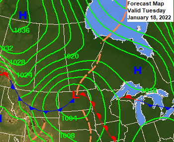
TUESDAY CLIPPER
A more organized clipper system is forecast to track east across northern North Dakota into northern Minnesota on Tuesday — This system may bring a few inches of snow (early estimates 1-4″) to much of the Northland on Tuesday with the highest amounts expected to be across northern Minnesota and over the Arrowhead (north of Duluth).
Thanks for reading!
Tim
Leave a Reply