5:38 PM Friday, February 11, 2022
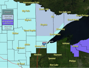
- WIND CHILL WARNING in effect from 9 PM this evening to 10 AM Saturday including the cities of Hibbing, Virginia, Hoyt Lakes, Ely, Tower, Cook, Orr, Crane Lake, Isabella, Tofte, Lutsen and Grand Marais. Wind chills as low as 45 below zero.
- WIND CHILL ADVISORY in effect from 9 PM this evening to 10 AM Saturday including the cities of International Falls, Bigfork, Grand Rapids, Cass Lake, Walker, Pine River, Brainerd, Hill City, Aitkin, Moose Lake, Cloquet, Duluth, Two Harbors, Silver Bay, Superior and Solon Springs. Wind chills as low as 40 below zero.
After Thursday’s snowfall, our Seasonal Snowfall Total (since Oct. 1) at Duluth, Minnesota for 2021-22 is at 56.4″, this is -1.4″ below normal to date. Percent of normal snowfall 98% of normal.
Winter 2021-22 (since Dec. 1) Snowfall total at Duluth, MN is at 50.9″, this is +10.5″ above normal. Percent of normal snowfall 126% of normal.
Peak Wind Gusts from Friday, February 11, 2022
Brainerd, MN: 46 mph
Duluth, MN (Airport) 45 mph
Hibbing, MN: 41 mph
International Falls, MN: 39 mph
Ashland, WI: 33 mph
We have seen the development of a gravity wave over western Lake Superior this afternoon which has caused an area of snow to develop from around Grand Marais southwest to Two Harbors to just east of Duluth, then this area of snow extends into northwest Wisconsin from just south/east of Superior toward the Bayfield Peninsula. This gravity wave is forecast to break down this evening with the area of snow coming to an end as well.
Seeing some decent convergence to feed into this snow band this afternoon with a NW wind in northeast Minnesota which shifts to the N and even NNE over western Lake Superior.


HRRR model wind chill forecast thru Noon Saturday.

Still seeing widespread arctic air covering much of Canada into parts of Alaska so there’s still plenty of cold air to tap into going forward.

Bitterly cold lows ahead this weekend, with lows tonight and Saturday night in the teens and 20s below zero in northeast Minnesota and northwest Wisconsin with some 30s below possible in the typical cold spots.

Highs on Saturday will only be in the single digits above zero across the Northland, and Sunday isn’t looking much warmer, with highs in the single digits and lower teens.

Lake effect snow showers will continue along the South Shore of Lake Superior in northwest Wisconsin tonight with an additional 1 to 4 inches of accumulation, while the rest of the Northland stays snow-free tonight.
18z NAM 3km model simulated radar forecast ending 6 AM Saturday.

More clippers on the way!
The first clipper with a little snow occurs late Saturday afternoon/Saturday evening, but this one looks like it will pass mostly west and south of the Northland.
Then, a second clipper looks to impact areas a little farther north/east compared to Saturday night’s clipper, and this clipper hits Sunday night with a few hours of snow possible in parts of the Northland the way it looks now.

SATURDAY NIGHT CLIPPER
Some light snow is possible Saturday evening over southern portions of the Northland, along and south of a line from Walker to Hayward with new snow accumulations of <1″.
18z NAM 3km model simulated radar forecast valid Noon Saturday to Midnight Sunday.

SUNDAY NIGHT CLIPPER
18z NAM 3km model simulated radar forecast valid Noon Sunday to Midnight Monday.


Snowfall Reports from February 10-11, 2022
2 N Lutsen, MN: 7.0″
Outing, MN: 5.5″
1 W Silver Bay, MN: 5.3″
4 NW Minong, WI: 5.0″
Aitkin, MN: 5.0″
Hayward, WI: 5.0″
Breezy Point, MN: 4.5″
Biwabik, MN: 4.1″
3 WSW Grand Marais, MN: 4.0″
Moose Lake, MN: 4.0″
Lester Park, MN: 4.0″
Wolf Ridge, MN: 3.9″
3 WNW Remer, MN: 3.7″
Wrenshall, MN: 3.5″
2.0 NW Stone Lake, WI: 3.5″
4 W Clam Lake, WI: 3.3″
6.8 ENE Sarona, WI: 3.3″
Two Harbors, MN: 3.2″
3 E Wright, MN: 3.1″
1.1 W Webb Lake, WI: 3.1″
Deerwood, MN: 3.0″
International Falls, MN: 3.0″
4.3 W Superior, WI: 3.0″
Duluth, MN (Airport) 2.9″
4 SE Danbury, WI: 2.9″
1.2 W Solon Springs, WI: 2.9″
2 NW Duluth, MN: 2.6″
Brainerd, MN: 2.5″
12 N Grand Rapids, MN: 2.5″
Littlefork, MN: 2.0″
Embarrass, MN: 1.8″
Thanks for reading!
Tim
Leave a Reply