5:57 PM Monday, February 21, 2022
Winter Storm continues!
Heavy lake effect snow bands continue near the head of Lake Superior affecting parts of the city of Duluth, northeast toward French River and Knife River along the North Shore, and east along the South Shore of Lake Superior out to the Bayfield Peninsula. Brief whiteout/blizzard conditions have been occurring under these lake effect snow bands today, and this should continue into this evening before a wind shift to the NNE takes place late tonight which should shift the lake effect/lake enhanced snow to the South Shore, mainly east of Duluth, but the snow will keep on falling in Duluth through Tuesday evening but without an added boost from Lake Superior.
Snow continues to move ENE through much of the Northland early this evening, but the snow has ended for now over southern portions of the area (white outlined area)
Heavier snowfall in green colors on the animation below.
Radar loop ending 5:45 PM Monday

Snowfall Reports for Monday, February 21, 2022
Note: Totals below are thru 5 PM Monday
5 W Washburn, WI: 19.0″
2 WSW Washburn, WI: 17.0″
4 WNW Washburn, WI: 14.0″
French River, MN: 12.0″
3 NE Duluth, MN: 8.7″
1 SE Cornucopia, WI: 7.0″
6 SE McGrath, MN: 7.0″
3 N Amnicon Falls State Park, WI: 6.3″
1 SW Hinckley, MN: 6.0″
Federal Dam, MN: 5.8″
3 E Payne, MN: 5.5″
2 NNE Duluth, MN: 5.5″
4 W Pleasant Valley, MN: 5.0″
Moose Lake, MN: 5.0″
7 WSW Pine River, MN: 4.0″
Based on reports of 15 to 19″ of snow already in the Bayfield Peninsula area in northwest Wisconsin today I did up their storm event totals to 25 to 35″, otherwise no other changes to my snowfall forecast at this time.

-Winter Storm Warning (pink area on map) continues through Tuesday night (ending between 6 PM and Midnight)
-Winter Weather Advisory (darker blue area on map) continues until 6 PM Tuesday.
-Wind Chill Advisory (light blue area on map) in effect from 7 PM this evening to 11 AM Tuesday.

A deep trough of low pressure over the western U.S. is sending pieces of energy ENE into the upper Midwest while arctic air (blue) moves south out of Canada while moisture (green) heads north from the Gulf of Mexico. This is a snowy setup for some parts of the Northland and this pattern will remain in place through Tuesday evening.
Goes-16 water vapor loop from Monday, February 21, 2022.

Strong jet streaks and ample amounts of lift occurring east of a trough centered over the Rockies has led to widespread snow in the Northland today.

Snow will continue to fall in northeast and east-central Minnesota and all of northwest Wisconsin through Tuesday night with this snow gradually ending from west to east after Midnight tomorrow night. There may be a few lulls in this snow later tonight, but even then, we may still see flurries or light snow falling from the sky.
As for areas of far northern Minnesota (Borderland) into the tip of the Minnesota Arrowhead — Best chances for snow for these areas will be this evening, but after that most of the snow looks like it will remain south/southeast of the aforementioned areas.
For Duluth — Snow through Tuesday evening. Snow ends between 1 AM and 4 AM Wednesday morning. The setup will remain favorable for heavier lake enhanced/lake effect snow this evening, but a wind shift to the NNE should shift the lake enhanced snowfall to areas east of Duluth overnight into Tuesday. Blowing and drifting snow will continue tonight and Tuesday with brief whiteout conditions continuing especially before Midnight tonight. Total storm event accumulations by 6 AM Wednesday of 12 to 18 inches with locally higher amounts possible.
Simulated radar forecast ending 6 AM Wednesday (snow in blue colors)

Strong east to northeast winds will continue near Lake Superior this evening with wind gusts of 30 to 45 mph. Winds will remain gusty overnight and through the day Tuesday although not quite as strong as what we’ve seen today but will still be dealing with wind gusts of 20 to 35 mph on Tuesday with a northerly wind direction.
Note: A peak wind gust out of the NE of 53 mph was reported today at Duluth Sky Harbor Airport
Wind gust forecast through 6 PM Tuesday.

Favorable ingredients remain in place over parts of the Northland for moderate to heavy snow potential this evening.
Strong warm air advection to our south.

Strong 700mb frontogenesis (purple outlined areas)

A deep DGZ (purple areas on map) leading to large snowflakes (higher snow rates)

A nearly 100-degree temperature contrast between Del Rio, Texas and International Falls, Minnesota late this afternoon. 94 at Del Rio and -4 at International Falls.
Here’s another one, 30 at Hays, KS and 70 at Topeka, KS.

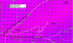
Arctic air remains over the Northland tonight and Tuesday, and likely for the rest of this week.
Lows tonight ranging from 15 below zero to around 5 above zero.

Highs in the single digits to around 10 above on Tuesday.

Thanks for reading!
Tim
Leave a Reply