5:41 PM Tuesday, March 1, 2022
Computer models are starting to come into better agreement on the track of this weekend’s system, but differences remain especially when it comes to precipitation types and amounts.
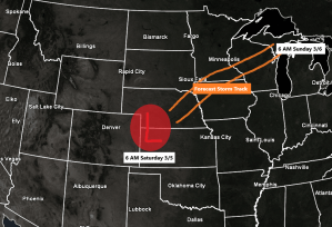
- Low pressure is forecast to be over northwest Kansas around daybreak on Saturday, this low is then forecast to lift northeastward, passing thru central Wisconsin to near or north of the Green Bay area around daybreak on Sunday.
- This system has the potential to bring a variety of precipitation types including snow, freezing rain and sleet to the Northland Saturday into Sunday.
- Significant amounts of snow and ice are possible in some parts of the Northland this weekend.
- Gusty northeast winds are also expected near Lake Superior including in Duluth from Saturday into early Sunday with wind gusts of 20 to 30 mph possible, and wind gusts may even end up higher than what is forecast today.

Chances that we see several hours of freezing rain and sleet are increasing in parts of the Northland Saturday afternoon into Saturday evening, with those chances currently highest south and east of the orange line on the animation below.
This icy mix of precipitation is due to a warm nose that lifts north into parts of the Northland Saturday afternoon and Saturday evening. Temperatures at ~5000 feet in the atmosphere (850mb) are forecast to climb to around +1 to +3C in eastern Minnesota and all of northwest Wisconsin while temperatures near the surface remain a few degrees below the freezing mark. This means that rain that falls to the surface will freeze on contact due to the below freezing near surface temperatures.
850mb temperature forecast valid 6 AM Saturday to 6 AM Sunday per 12z European model.

Here’s the 18z GEFS model (20 member) Precipitation Type forecast valid at 6 PM Saturday, March 5, 2022.
Blue=Snow
Pink=Icy mix (freezing rain or sleet)
Green=Rain
Out of the 20 members, there’s only 2 that show this weekend’s storm missing the Northland to the south, will see if that number increases over the next day or two.

THUNDERSTORM POTENTIAL
There is even a chance that we see a few thunderstorms in southern parts of the Northland Saturday afternoon into Saturday night as we could get enough elevated instability to push north out of southern Minnesota and into parts of our area later Saturday. So, perhaps some thundersleet or thunder freezing rain late Saturday?
CAPE forecast valid Noon Saturday to Midnight Saturday night (higher instability in darker gray and blue colors)

The clash of the airmasses!
The storm this weekend could produce a few severe thunderstorms from northern Missouri into central Iowa (yellow area on map)

Ensemble models total precipitation forecast for this weekend
One thing the three ensemble models agree on is for the lowest amounts of precipitation to be across far northern Minnesota including the International Falls area.
Precipitation totals trend higher the farther south you go in the Northland, with the highest amounts forecast to setup from east-central Minnesota into all of northwest Wisconsin the way it looks now.


Much of the Northland has a good chance to pick up 4 inches or more of snow this weekend, except in the darker blue areas on the map, those areas have a lower chance to pick up 4 inches or more of snow this weekend.

We have one more weak system embedded in the NW flow aloft which will pass SE across the region late tonight into Wednesday morning. This disturbance will bring a little snow at times to the Northland Wednesday morning.
Radar forecast valid Midnight tonight to 10 AM Wednesday (snow in blue colors)

Less than an inch of snow is forecast in the Northland thru Noon Wednesday.

Thanks for reading!
Tim
Leave a Reply