7:41 PM Sunday, March 20, 2022
A complex storm system will be affecting the Northland over the next few days with the time frame for heavier precipitation starting late Monday evening/Overnight and lingering through early Wednesday morning.
An initial round of scattered rain showers or mixed rain, freezing rain and ice pellets is possible early Monday morning over parts of northeast and east-central Minnesota into northwest Wisconsin, but no major impacts are expected with this band of precipitation since it isn’t expected to last very long, but for areas that do get freezing rain it may put down a light glaze of ice early Monday morning.
For Duluth and Superior — Some light rain, patchy freezing rain/ice pellets is possible Monday morning from around 5 AM to 7 AM, after that it looks mainly dry for the rest of the day Monday.

The main time frame for more significant precipitation in the Northland comes Monday night and lingers through early Wednesday morning.
Simulated radar forecast valid 7 PM Monday to 7 PM Wednesday per 12z European computer model.
Snow in blue
Rain in green
Freezing rain and sleet in pink/purple colors

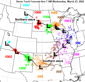
As I alluded to, this is a complex storm with a northern wave and southern wave.
The northern wave moves SE out of the western Dakotas and reaches southern Minnesota late Monday while a stronger southern wave lifts NE out of the Southern Plains, with this low eventually moving into central Illinois around daybreak on Wednesday.
A large mid-upper-level trough approaching from the west, combined with southerly winds ahead of this trough will help draw abundant low-level moisture northward from the Gulf.
Temperatures from the surface to a few thousand feet in the atmosphere will be borderline to where we could see a lot of snow and or ice to where we see mostly rain, with only minor amounts of snow and ice.

Here is what I have for an early forecast of snowfall totals for Tuesday into Wednesday, but I’m pretty sure I’ll be updating this forecast a few times before Tuesday. Stay tuned!
This will likely be a wet/slushy type of snow with a high-water content.

There is still a lot of ice covering Lake Superior, and we should see some of this ice shift farther west to the North Shore down to the head of Lake Superior over the next few days as winds become east to northeast. This ice pack may help keep temperatures cold enough to where we see more frozen precipitation vs. liquid precipitation for areas near Lake Superior Monday night through Wednesday.

~50 to 55% of Lake Superior was covered by ice as of March 19, 2022 — This is down from a peak of ~80% earlier this month. Normal ice coverage at this time of year is ~35 to 40%.

Big time problems in parts of Texas today with explosive fire weather conditions in place.
-Very warm temperatures of around 80 degrees
-Very low relative humidity values
-Strong southerly winds 20-30 mph

Net result from the above-mentioned ingredients is this — Widespread wildfires erupting in north-central to northeast Texas today (yellow outlined areas on map) with smoke plumes from those fires pushing northward thanks to the southerly low-level winds today.

Rare Fire Warnings (brown outlined areas) in effect in parts of Texas late this Sunday afternoon.

What a beautiful first day of spring it was in the Northland today.
High temperature reports from March 20, 2022
Ashland: 56 F
Duluth: 55 F (warmest temperature since November 7, 2021, high of 56 F)
Brainerd: 55 F
International Falls: 53 F
Hibbing: 52 F
Thanks for reading!
Tim
Leave a Reply