5:44 PM Thursday, April 14, 2022
The pattern stays active through at least the middle of next week.
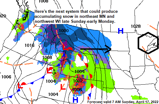
The current system affecting the Northland will finally pull off to the east on Friday, but behind it will be another system which moves east out of the Northern Plains Sunday through early Monday, and a third system may move through the Northland around the middle of next week (~April 19-20).
Snow showers will linger in northeast Minnesota and northwest Wisconsin tonight with heavier snow squalls and gusty winds continuing through early this evening with brief whiteout conditions possible.
At least some partial sun is expected on Friday but will also be dealing with gusty winds and possibly some more flurries and snow showers although coverage of these snow showers shouldn’t be as widespread compared to what we saw Thursday.
Temperatures at 4 PM on April 14 are only in the teens in northern North Dakota (white outlined area)
Snow showers and snow squalls continue to move east across the region on the west and south side of a strong upper low which was over far northeast Minnesota late this afternoon.

500mb forecast through Monday, April 18, 2022.
Lower 500mb heights/unsettled weather in blue, green, and purple colors on the animation below.

There’s no doubt about it that Spring 2022 has been cool and wet in Duluth and throughout the entire Northland.
Here are some stats for Spring 2022 at Duluth, Minnesota, the stats below are from March 1 through April 14.
*Average temperature 27.1 F, -2.5 degrees below average.
*3.33″ of precipitation, 131% of normal.
*21.7″ of snow, 120% of normal.
*14.8″ of snow so far this month, 279% of normal.
*8 days so far this month with at least 0.1″ of snow, normal in April is 8 days.
*7 days so far this month with at least 1.0″ of snow, normal in April is 2 days.
*Only 1 day with a high of 50 F or warmer so far this month. Average number of days with a high of 50 F or warmer in April is 13 days.
*There’s only been 2 days so far this year with a high of 50 F or warmer, the warmest being 55 degrees on March 20.
*Only 2 days so far this month with no precipitation, the other 12 days have had at least a trace or more of precipitation.
2021 was -5.47″ below normal in precipitation at Duluth, Minnesota, while in 2020 Duluth finished -9.70″ below normal in precipitation. Those two years combined -15.17″ below normal.
In weather things tend to balance out, and about the only way to erase the drought that has plagued the Northland over the last two years was for a pattern like the one we’ve seen this spring featuring numerous precipitation events. The question now becomes does this active pattern stick around into May and beyond, or does it become less active? Time will tell.
More frequent low-pressure systems have been hitting the Northern Plains and upper Midwest in 2022 and this has led to a major improvement in drought conditions especially over the Dakotas where this time last year much of western and central North Dakota into northwest South Dakota were in Extreme Drought.
Drought has intensified this year compared to this time last year in parts of the Central Plains (black outlined area on map)

Here’s a look at the Drought Monitor Class Change for the last 3 months, or from April 12, 2022, compared to January 11, 2022.
Green colors represent improving drought conditions while yellow and brown colors represent worsening drought conditions.

Simulated radar forecast through 7 PM Friday.
Snow (blue)

An unusually strong upper-level trough/low continues to move east across the Northland this afternoon.
Goes-16 visible satellite loop from Thursday, April 14, 2022.

And a look at the current storm, which is far reaching, from west-central Canada to the Great Lakes to the eastern U.S.
Goes-16 water vapor loop from Thursday, April 14, 2022.

Check out what the European computer model is serving up for late next week/next weekend, a summer like pattern featuring a trough (blue) over the western U.S. while a big ridge covers the Plains, upper Midwest and Great Lakes (orange and red)
500mb forecast valid Friday, April 22 through Monday, April 25, 2022.

Under the aforementioned ridge we could be talking about daytime highs in the 70s and 80s next Friday and Saturday over much of Minnesota and Wisconsin (cooler near Lake Superior), with 90s possible over parts of South Dakota via European computer model forecast.

Thanks for reading!
Tim
Leave a Reply