5:41 PM Wednesday, April 20, 2022
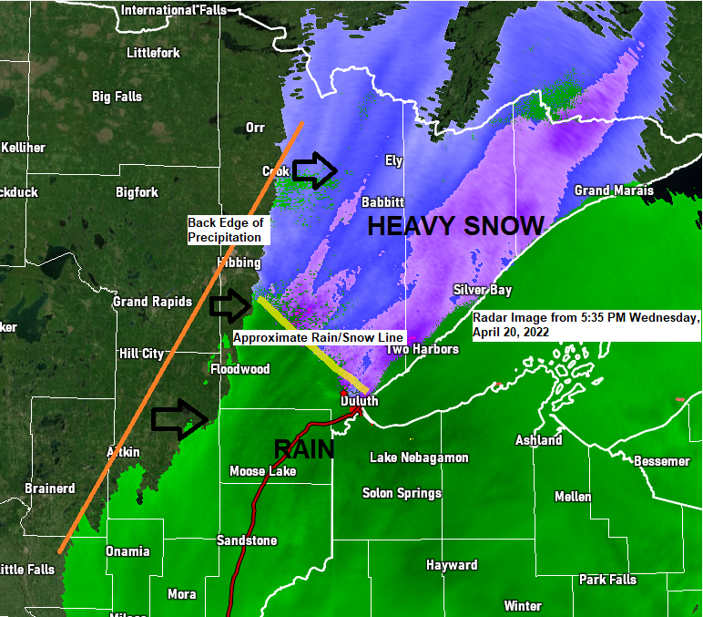
A strong but quick moving area of low pressure brought widespread precipitation to northeast Minnesota and northwest Wisconsin today with wet snow across northern Minnesota and Arrowhead while rain was the main precipitation type farther south from east-central Minnesota into northwest Wisconsin.
Precipitation totals ranging from around a quarter to half inch are expected in much of the Northland through this evening.
Will dry out Thursday with partial sunshine, but we will be dealing with gusty west to northwest winds from late tonight through the day Thursday with wind gusts of 20 to 30 mph in northeast Minnesota and northwest Wisconsin.
Highs on Thursday will range from the lower 40s in northern Minnesota to around 50 from the Brainerd Lakes east into northwest Wisconsin. Note: Normal highs on April 21 range from 52 to 57 degrees in the Northland.
Snowfall Reports from around the Northland for Wednesday, April 20, 2022
International Falls, MN: 2.3″
Federal Dam, MN: 1.8″
12 N Grand Rapids, MN: 1.5″
7 WSW Pine River, MN: 1.0″
Snow will continue into early this evening in northern Minnesota with areas of heavy snow possible.
Rain continues into early this evening from eastern Minnesota into northwest Wisconsin including in Duluth.
Precipitation will end from west to east through this evening with precipitation ending in Duluth around 7-8 PM this evening.
Simulated radar forecast through Midnight
Snow (blue)
Rain (green)

A webcam image showing the snow that is falling late this afternoon in the Arrowhead of Minnesota, this particular image is from the Grand Marais Harbor Cam at 4:41 PM Wednesday.

A look at today’s system via Goes-16 visible satellite imagery.

And on Goes-16 water vapor imagery — An impressive looking system moving east out of southern Saskatchewan this afternoon.

A strong spring storm will affect the Northern Plains and upper Midwest this weekend.
Heavy snow and strong winds will be found in the colder air on the NW side of the low while occasional showers and thunderstorms occur in the warmer air to the SE/E of the low.
The Northland will be on the warmer side of the storm track this weekend as low pressure passes NE through the Dakotas so rain will be the main precipitation type from Friday through Sunday morning.
Currently it looks like the Friday night-Saturday evening time frame holds the greatest potential for more widespread showers in northeast Minnesota and northwest Wisconsin, but scattered showers will probably linger into early next week, and as colder air moves in behind the low, we could see the rain mix with or change to snow from late Sunday through Monday, but no snow accumulation is expected in our area the way it looks now.
Some thunderstorms are also possible in the Northland Friday night through Saturday evening as elevated instability increases. The main hazards from these storms will be from lightning and heavy downpours, but some small hail can’t be ruled out especially Friday night when a plume of steep mid-level lapse rates pushes through the area.

There continues to be some uncertainty on how far north a warm front will get on Saturday, but if it lifts far enough north, then we could see some 70s in southern parts of the Northland Saturday afternoon with 50s in northern Minnesota, and 40s near Lake Superior due to a NE wind.
Note: This warmup will be short lived, however, as colder temperatures look to return next week.

Runoff from snowmelt combined with the rain that is forecast to fall this weekend may lead to some flooding across northern Minnesota, west into central/eastern North Dakota.
There is a marginal risk (at least 5% chance) for rainfall to exceed flash flood guidance in the green shaded area Friday night through 7 AM Saturday.

Another winter storm is possible this weekend over parts of the Northern Plains with a potential for 6-12″ or more of snow especially over western parts of North Dakota.

Thanks for reading!
Tim
Leave a Reply