8:04 PM Saturday, June 4, 2022
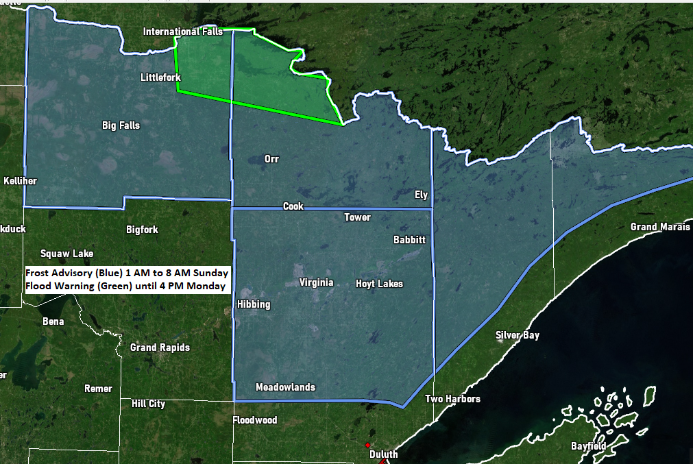
A Frost Advisory is in effect from 1 AM to 8 AM Sunday for parts of northeast Minnesota including the cities of International Falls, Littlefork, Big Falls, Orr, Cook, Crane Lake, Ely, Hibbing, Virginia, Cotton, Canyon, Meadowlands, Hoyt Lakes, Wales, Isabella, and Forest Center. Low temperatures of 33 to 36 will result in frost formation.
*FLOOD WARNING UPDATE*
-Flood Warning remains in effect until early Friday morning for the Mississippi River at Aitkin affecting Aitkin and Crow Wing Counties. Minor flooding is occurring, and minor flooding is forecast. At 8:30 AM Saturday the stage was 13.7 feet. Flood stage is 13.0 feet. The river is expected to fall below flood stage Thursday morning and continue falling to 12.4 feet next Saturday morning.
-Flood Warning remains in effect until 4 PM Monday for portions of north-central and northeast Minnesota including the following counties Koochiching and St. Louis. Namakan and Kabetogama Lakes were at 1122.3 feet as of June 3, which is 22 inches above the peak level set in 2014 and 6 inches below the 1916 peak. The level of Namakan Lake is expected to fall by 2 to 3 inches between June 4 and June 10. Rainy Lake was at 1112.9 feet as of June 3 which is 19 inches above the 2014 flooding peak and matches the record peak of 1950. Rainy Lake is expected to rise by 9 to 10 inches between June 4 and June 10. A peak is unlikely before mid-June on Rainy Lake regardless of precipitation patterns. Some locations that will expierence flooding include International Falls, Kabetogama, Crane Lake, Kabetogama Lake, Voyageurs National Park, Rainy Lake East, Rainy Lake West, northwestern Boundary Waters Canoe Area Wilderness, Ranier, Ray, Island View, Ericksburg, Johnson Lake and Sand Point Lake.
*Hinckley, Minnesota Tornado Information*
Rating: EF-1
Estimated Peak Wind: 95 mph
Path Length: 3.3 miles
Path Width /maximum/: 300 yards
Fatalities: 0
Injuries: 0
Start Date: May 30, 2022
Start Time: 7:50 PM CDT
Start Location: Hinckley, MN (Pine County)
End Date: May 30, 2022
End Time: 7:54 PM CDT
End Location: 2 miles south of Friesland, MN (Pine County)
Although it was a very pleasant (mild) early June day in the Northland, temperatures this morning started off on the chilly side in parts of the area. Here are the low temperature reports from Saturday morning, June 4, 2022.
Hibbing, MN: 33
Hayward, WI: 34
Eveleth, MN: 34
Solon Springs, WI: 34
Ashland, WI: 35
Grand Marais Airport: 36
International Falls, MN: 36
Two Harbors, MN: 37
Hinckley, MN: 37
Superior Airport: 38
Siren, WI: 38
Grand Marais, MN: 39
Ely, MN: 39
As I alluded to earlier in this post it was a very pleasant early June day in the Northland with widespread low to mid 70s for daytime highs, with near 80-degree temps reported at Superior and the Duluth Harbor (both locations had a high of 79)
This is by far one of the longest stretches we’ve had in quite some time without any significant precipitation across northeast Minnesota and northwest Wisconsin.
A mostly dry weather pattern is expected to continue in the Northland at least for the next 5 to 7 days, yes there may a passing shower on occasion through late next week, but certainly no widespread soaking rains impacting the Northland through at least late next week the way it looks now.

Nothing really standing out when it comes to the high temperature forecast through next Friday (June 10) as daytime highs are forecast to range from the low 60s to low 70s in northeast Minnesota and northwest Wisconsin.
Thanks for reading!
Tim
Leave a Reply