6:18 PM Tuesday, July 5, 2022
- Dense fog returns near Lake Superior tonight and lingers into Wednesday morning.
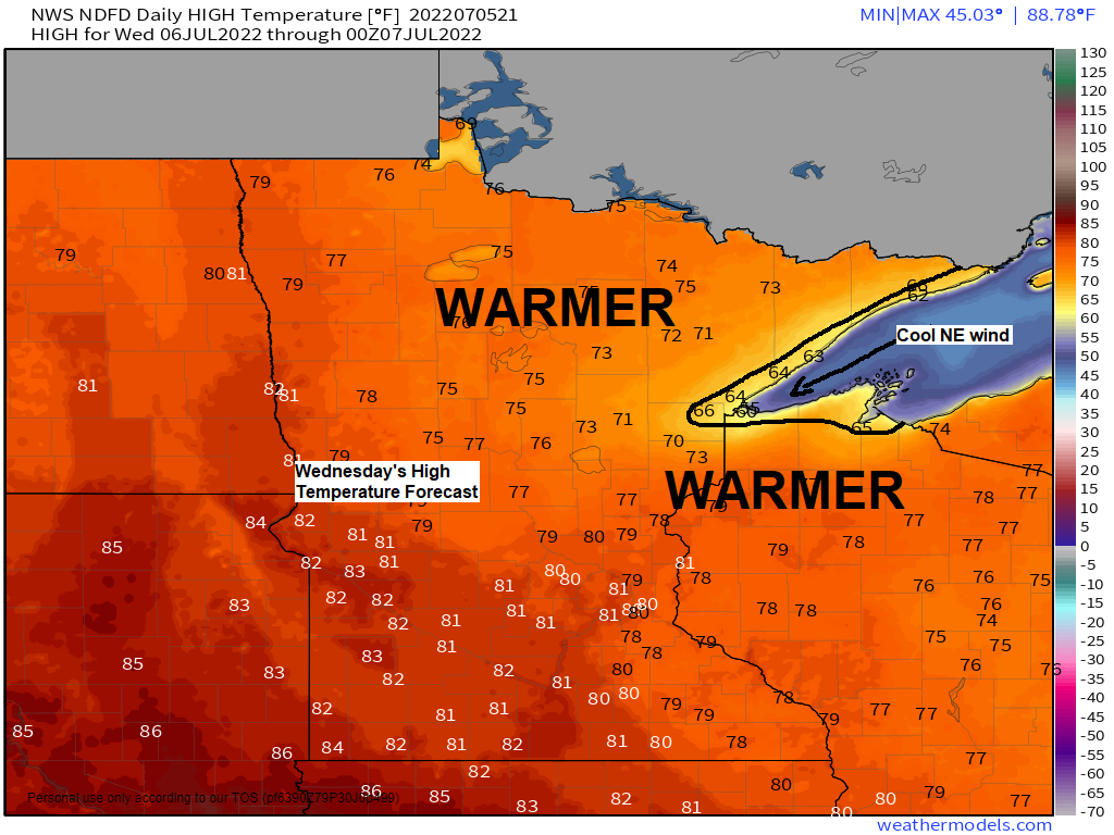
- A gusty and cool NE wind near Lake Superior Wednesday, warmer temps inland.
- A brief warmup near Lake Superior Thursday, highs approaching 80, but a cooler lake wind returns Friday and Saturday.
- Next chance for a more widespread rain event for the Northland comes late this weekend into early next week.
Areas of dense fog will be found once again near Lake Superior tonight into Wednesday morning as a cool and humid onshore flow continues off Lake Superior.
HRRR model visibility forecast through 9 AM Tuesday.
Lower visibility in the pinkish colors on the animation below.

The next few days continue to look mostly dry in northeast Minnesota and northwest Wisconsin although isolated showers can’t be ruled out on Thursday as a cold front moves through the area, but a greater chance for some showers and thunderstorms returns late this weekend and early next week as a pretty strong trough and cold front moves through the area.

A derecho continues to move east-southeast across parts of southern and eastern South Dakota late this afternoon. So far there’s been nearly 70 reports of wind damage today (thru 3 PM) associated with this derecho which moved across much of South Dakota today.
Top wind gusts from today’s derecho in South Dakota.
3:53 PM – 85 to 90 mph, Wall Lake area (southwest of Sioux Falls)
2:10 PM – 80 mph, Woonsocket, SD.
2:03 PM – 96 mph, 2 miles north-northwest of Huron, SD.
12:38 PM – 87 mph, 1 mile north Ree Heights, SD.
11:26 AM – 91 mph, 4 miles north Agar, SD.
9:40 AM – 84 mph, 1 mile south-southwest of Timber Lake, SD.

Goes-16 infrared satellite loop of today’s derecho from Tuesday, July 5, 2022.

Derecho continues on its ESE path as it moves across the northwest half of Iowa late this afternoon while additional severe thunderstorms erupt over northeast Iowa and far southern Wisconsin out ahead of the main line of storms to the west.
MRMS radar loop ending 6:10 PM Tuesday, July 5, 2022.

Ingredients came together for a higher end severe weather event today in parts of the Northern Plains and upper Midwest.

Such a classic/textbook Ring of Fire weather pattern in place today where you have sinking air and generally clear skies near the core of an upper-level ridge across the Central Plains while clusters of strong to severe thunderstorms producing swaths of wind damage and large hail erupt around the periphery of the ridge. Cool stuff!

80+ degree temperatures as far north as Fort McPherson Canada (Northwest Territories) today while temperatures are in the low 50s near Lake Superior at the Duluth Harbor and Superior, while the Midwest and Southern US continue to bake with widespread temperatures of around 95 to 105 degrees today.

Watch the evolution of a strong upper-level ridge (heat dome) through late next week on the animation below.
The ridge starts out over the southern US but retrogrades to the west as it sets up over the Rockies this weekend into much of next week. 500mb heights could approach 600 decameters at times near the center of this ridge this weekend into next week, that’s big-time stuff!
With the heat dome centered well to the SW of the Northland this will help keep our area in a NW flow aloft through next week which means the core of the heat stays well to the south/west of our area, with generally more seasonable temperatures in the 70s and low-mid 80s expected in northeast Minnesota and northwest Wisconsin through early next week.
500mb height anomaly forecast valid July 6 – July 15, 2022.

Thanks for reading!
Tim
Leave a Reply