5:15 PM Wednesday, August 17, 2022
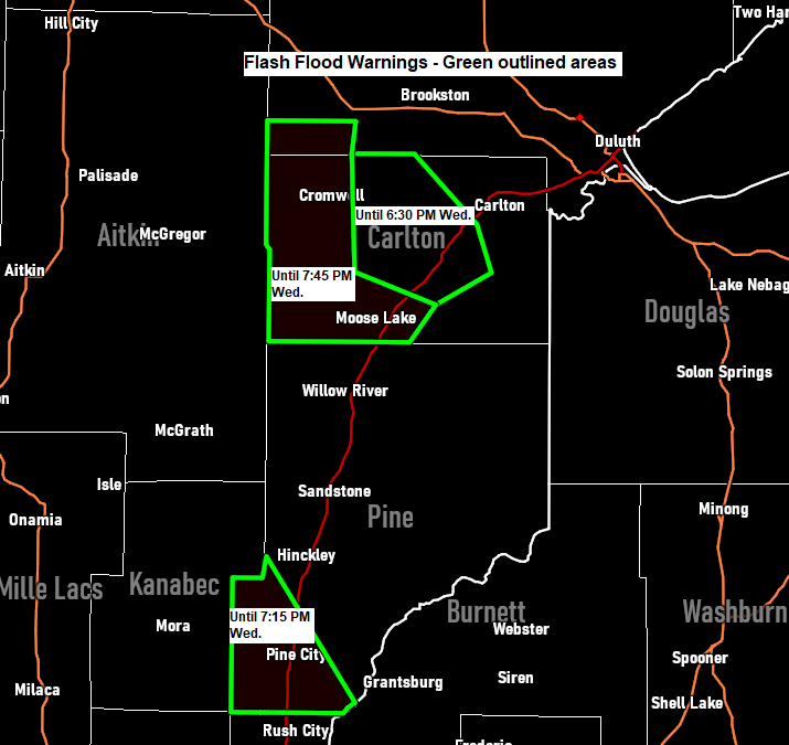
- FLASH FLOOD WARNING until 6:30 PM this evening for central Carlton County and southern St. Louis County in northeast Minnesota including Cloquet, Mahtowa, Barnum, Fond Du Lac Band Sawyer area, Fond Du Lac Band Cloquet Area, Big Lake, Sawyer, and Kettle Lake.
- FLASH FLOOD WARNING until 7:30 PM this evening for southwest Pine County in east central Minnesota including Pine City, Rock Creek, Brook Park, Henriette, West Rock, Beroun, Greely, and Chengwatana State Park.
- FLASH FLOOD WARNING until 7:45 PM this evening for western Carlton County and southwest St. Louis County in northeast Minnesota including Moose Lake, Barnum, Cromwell, Wright, Kettle River, Automba, Prairie Lake, and Moose Lake State Park. Expect rises on the Moose Horn, Kettle and Tamarack rivers.
IMPACTS in the Flash Flood Warning areas — Flash flooding of small creeks and streams, urban areas, highways, streets and underpasses as well as other poor drainage and low-lying areas.
Thunderstorms have been producing torrential rainfall rates in parts of eastern Minnesota today, with two areas in particular which have seen very heavy rainfall rates this afternoon (1-2″+ hourly rates per radar estimates) one area was central Carlton County, the other area was in southwest Pine County.
Note: Flash Flood Warnings – Green outlined areas on image below.

SHORT TERM
There isn’t going to be a whole lot of change in our weather at least through Friday with more chances for scattered showers and thunderstorms.
Weak winds aloft and very little wind shear means that these storms will be relatively slow moving and pulsey in nature, and with abundant moisture in place, the potential for heavy rain and isolated flash flooding will probably continue across parts of the Northland through Friday.
Note: Areas that see storms back build will be most susceptible for flash flooding, but again the overall flood threat will continue to be fairly isolated in our area.
HRRR model radar forecast through 9 AM Thursday.

24-Hour Rainfall Reports for August 16-17, 2022, thru 4 PM Wednesday, August 17, 2022.
Source: MesoWest
Seagull Lake, MN: 1.86″
Duluth Airport: 1.72″
Deer River, MN: 1.34″
Saginaw, MN: 1.23″
Grand Rapids, MN: 1.12″
Isabella, MN: 1.09″
Webb Lake, WI: 1.05″
Duluth Sky Harbor Airport: 1.01″
Winton, MN: 0.86″
South Range, WI: 0.73″
Spooner, WI: 0.72″
Shell Lake, WI: 0.67″
Solon Springs, WI: 0.59″
Odanah, WI: 0.59″
Aurora, MN: 0.57″
Barnes, WI: 0.49″
Minong, WI: 0.43″
Bayfield, WI: 0.43″
Washburn, WI: 0.40″
Eveleth-Virginia, MN: 0.37″
Esko, MN: 0.35″
Longville, MN: 0.34″
Chisholm-Hibbing Airport: 0.30″
Ely, MN: 0.27″
Hinckley, MN: 0.26″
Cloquet, MN: 0.24″
Two Harbors, MN: 0.21″
Kettle River, MN: 0.18″
French River, MN: 0.16″
Brainerd, MN: 0.16″
Effie, MN: 0.15″
Danbury, WI: 0.12″
Ashland, WI: 0.12″
Poplar, WI: 0.07″
Grand Marais, The Bay of Grand Marais, MN: 0.07″
McGregor, MN: 0.06″
Siren, WI: 0.05″
Hayward, WI: 0.05″
Clam Lake, WI: 0.04″
Cable, WI: 0.02″
Cass Lake, MN: 0.02″
Glidden, WI: 0.02″
Here’s a look at today’s convection which has been impacting parts of northern/eastern Minnesota and northwest Wisconsin today via Goes-16 infrared satellite imagery with colder cloud tops (thunderstorms) in yellow and orange on the animation below.

Expect a continuation of scattered showers and thunderstorms with torrential downpours in the Northland over the next few days with computer models targeting western/southern portions of the Northland for the most activity/highest rain totals with a potential for an additional 0.50″ to 2.00″ or more of rain through Saturday. The least amount of rain is expected along the North Shore and especially over the Minnesota Arrowhead.

HREF model also targets western/southern portions of the Northland for a potential of excessive rainfall totals which could exceed 3 inches in isolated spots through Friday morning.

HRRR model radar forecast valid 10 AM Thursday to 7 PM Thursday.

Thanks for reading!
Tim
Leave a Reply