4:39 PM Wednesday, August 24, 2022
- Scattered showers and a few thunderstorms will continue tonight in portions of the Northland with a potential for heavy downpours.
- Drier weather returns Thursday and Friday.
- Gusty northeast winds continue near Lake Superior tonight into Thursday morning with wind speeds and gusts diminishing Thursday afternoon.
- Highs in the upper 60s to middle 70s Thursday, and from the mid 70s to around 80 Friday. Highs this weekend look to be in the 70s to lower 80s.
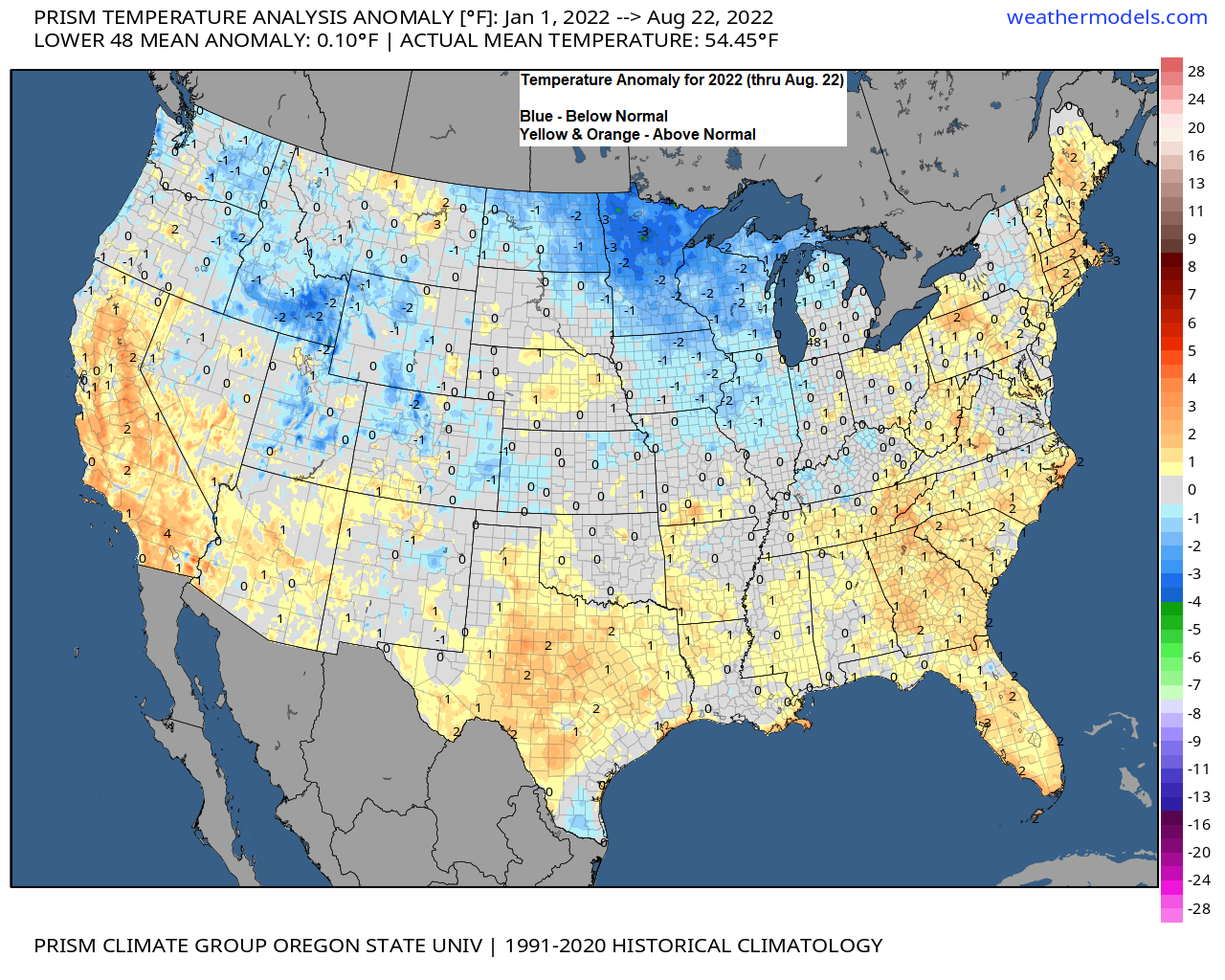
Cooler than normal temperature anomalies cover much of North Dakota, all of Minnesota, all of Wisconsin and all of upper Michigan so far this year.
Average temperature and departure from normal for 2022 (thru Aug. 23)
Brainerd, MN: 39.7 F
Departure: -2.9 degrees below normal
Duluth, MN: 38.9 F
Departure: -3.0 degrees below normal
International Falls, MN: 36.2 F
Departure: -2.9 degrees below normal
Hibbing, MN: 35.5 F
Departure: -3.0 degrees below normal

We still have a few more months left in 2022, but currently this year is tied for coldest year on record by climate district in northeastern Minnesota (1893-2022) while parts of northern Minnesota are having a top 10 coldest year on record (1893-2022).

So far this month Duluth has had a few more days which have been cooler than normal (blue) compared to the number of days which have been warmer than normal (red)
48% of days this month have had a below normal temperature compared to 39% of days which have been above normal this month (thru the 23rd)

Radar rainfall estimates over the last 12 hours ending 4 PM today.

24-Hour Rainfall Totals for August 23-24, 2022 (ending 4 PM on the 24th)
Source: MesoWest
Siren, WI: 2.10″
Deer River, MN: 1.86″
Pine River, MN: 0.82″
Hinckley, MN: 0.60″
Shell Lake, WI: 0.57″
Spooner, WI: 0.55″
Danbury, WI: 0.54″
Orr, MN: 0.49″
Bigfork, MN: 0.46″
Webb Lake, WI: 0.37″
Chisholm-Hibbing Airport: 0.36″
Hayward, WI: 0.27″
International Falls, MN: 0.26″
Walker, MN: 0.26″
Winter, WI: 0.25″
Schroeder, MN: 0.21″
Cass Lake, MN: 0.21″
Isabella, MN: 0.17″
Minong, WI: 0.17″
Cable, WI: 0.15″
Grand Marais, MN: 0.11″
Brainerd, MN: 0.10″
Eveleth-Virginia, MN: 0.07″
Solon Springs, WI: 0.06″
Duluth Airport: 0.02″
Grand Rapids, MN: 0.01″
Scattered showers along with a few thunderstorms will linger into tonight in parts of the Northland but these showers should diminish later tonight.
HRRR model radar forecast through 7 AM Thursday.

Highest rain amounts tonight will be away from Lake Superior.
Here in Duluth rain chances remain on the low side for tonight with just some patchy drizzle or possibly a few passing showers expected.

Much of the Northland saw quite a cool down today compared to the 80+ degree temperatures we had the last few days.
Temperatures this afternoon are mostly in the 60s and 70s in northeast Minnesota and northwest Wisconsin.

Temperatures are running about -10 to -20 degrees cooler this afternoon compared to Tuesday afternoon in much of northern and northeast Minnesota, and in northwest Wisconsin.

Thanks for reading!
Tim
Leave a Reply