4:55 PM Monday, August 29, 2022
Today (Monday) was likely our coolest day of the week as highs today were generally in the mid 60s to low-mid 70s across the Northland.
A warming trend begins Tuesday with highs in the 70s, with even warmer temperatures expected Wednesday, Thursday and Friday with highs getting into the 80s in parts of the Northland, and those that fail to climb into the 80s will still be in the mid to upper 70s, not bad at all as we head toward the end of meteorological summer (August 31) and head toward the start of meteorological fall (September 1).
About the only real weather issue the next few days will be continued breezy northwesterly winds with gusts to 25 mph expected again Tuesday and Wednesday.
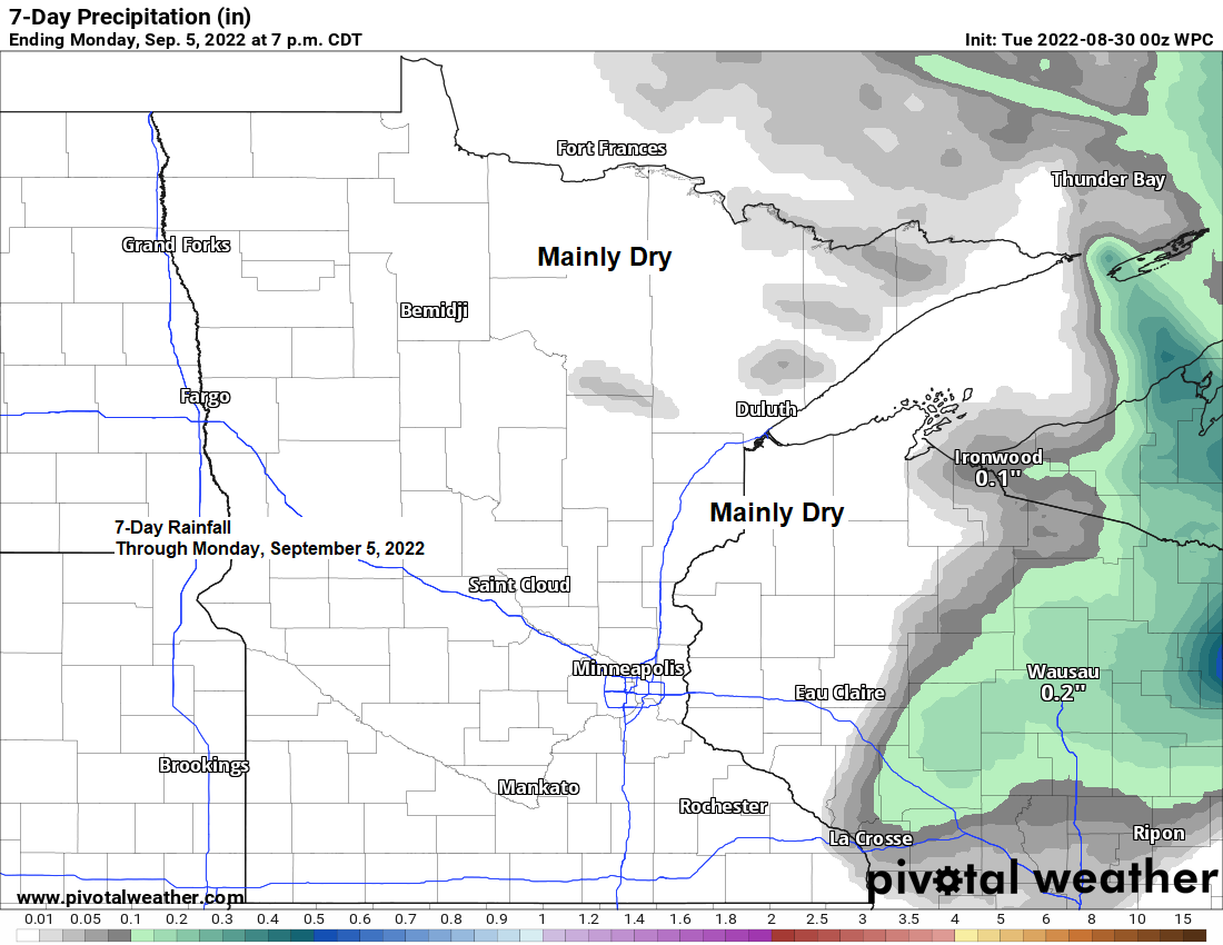
Little if any rain chances ahead in the Northland at least through early next week, but a cold front will be moving across the Northland on Friday but at the moment it doesn’t look like will get any precipitation with that frontal passage.
Local Storm Reports from Sunday night-early Monday morning, August 28-29, 2022.
Source: NWS Duluth, MN
1:35 AM 8/29: Marine Thunderstorm Wind 40 mph. 13 NE Sand Bay, WI at Devils Island Lighthouse.
12:35 AM 8/29: Thunderstorm Wind Damage. 5 NW Hayward, WI (Washburn County) Law enforcement from Washburn and Sawyer Counties reported that there were several locations within each county with smaller trees and branches down due to strong winds.
12:08 AM 8/29: Thunderstorm Wind Damage. 1 W Solon Springs, WI (Douglas County) A sign was blown over near mile marker 202 along Highway 53 near Solon Springs.
10:00 PM 8/28: Hail 0.25 inch. 4 SE Coleraine, MN (Itasca County)
9:49 PM 8/28: Hail 0.75 inch. 2 NE La Prairie, MN (Itasca County)
9:47 PM 8/28: Hail 0.50 inch. 4 W Blackberry, MN (Itasca County)
9:46 PM 8/28: Hail 0.50 inch. 1 N Grand Rapids, MN (Itasca County)
9:45 PM 8/28: Hail 0.75 inch. 5 S La Prairie, MN (Itasca County)
9:44 PM 8/28: Hail 0.50 inch. 1 W Grand Rapids, MN (Itasca County)
8:50 PM 8/28: Hail 1.50 inch (ping pong ball size hail) Boy River, MN (Cass County)
8:47 PM 8/28: Hail 0.25 inch. Boy River, MN (Cass County)
8:40 PM 8/28: Hail 1.75 inch (golf ball size hail) Brevik, MN (Cass County)
8:15 PM 8/28: Hail 0.70 inch. 1 NNE Walker, MN (Cass County)
Here’s a look at radar estimated rainfall totals from Sunday night through early Monday morning.
Note that dry pocket outlined in white stretching from far northern Pine County through parts of Carlton and Douglas County while heavier rain fell north and south of that area.

Rainfall Reports from Sunday evening-early Monday morning, August 28-29, 2022.
Source: NWS Duluth, MN
2.8 NE Oliver, WI: 2.85″
5 NNW Knife River, MN: 2.53″
4 NE Rice Lake, MN: 2.50″
2.4 S Meadowlands, MN: 2.14″
11.8 NNE Duluth, MN: 2.11″
0.5 E Floodwood, MN: 1.82″
1 WSW Two Harbors, MN: 1.78″
7 N McGregor, MN: 1.64″
Cotton, MN: 1.62″
Two Harbors, MN: 1.51″
0.2 W Culver, MN: 1.46″
Silver Bay, MN: 1.04″
French River, MN: 1.01″
Hill City, MN: 0.77″
Schroeder, MN: 0.73″
9 N Bayfield, WI: 0.71″
Chisholm-Hibbing Airport: 0.67″
Danbury, WI: 0.66″
Walker, MN: 0.58″
Lutsen, MN: 0.56″
Libby, MN: 0.55″
Duluth Airport: 0.52″
Grand Rapids, MN: 0.50″
Deer River, MN: 0.46″
Minong, WI: 0.41″
Saginaw, MN: 0.39″
Cass Lake, MN: 0.38″
Shell Lake, WI: 0.38″
Webb Lake, WI: 0.37″
Grand Marais, MN: 0.28″
Hayward, WI: 0.26″
Isabella, MN: 0.25″
Cook, MN: 0.22″
Embarrass, MN: 0.20″
Siren, WI: 0.18″
Glidden, WI: 0.13″
Ely, MN: 0.09″
Aurora, MN: 0.05″
Hurley, WI: 0.05″
International Falls, MN: 0.04″
Esko, MN: 0.03″
Poplar, WI: 0.03″
Winter, WI: 0.02″
Washburn, WI: 0.02″
Ashland, WI: 0.01″
With only a couple days left of meteorological summer 2022 (first day of meteorological fall is September 1), let’s take a look at how we’re doing temperature wise for this summer.
Average temperatures for the summer of 2022 have been running very close to normal, generally within a degree either above normal or below normal in northeast Minnesota and northwest Wisconsin – See below.
Brainerd, MN: 69.0 F
Departure: +1.5 degrees above normal
Duluth Airport: 64.7 F
Departure: +0.1 degrees above normal
Superior, WI: 64.5 F
Departure: +0.5 degrees above normal
International Falls, MN: 64.0 F
Departure: +1.0 degree above normal
Hibbing, MN: 62.0 F
Departure: +0.6 degrees above normal
Two Harbors, MN: 60.6 F
Departure: -1.6 degrees below normal
Note: 22 days so far this summer with a high temperature of at least 80 degrees in Duluth. Normal for the summer is 25 days with a high of at least 80. It doesn’t look like will be adding anymore 80-degree days to this summer’s total, so it looks like will finish slightly below normal on the number of 80-degree days we normally get during the summer in Duluth. Last summer had a total of 46 days with a high of at least 80 in Duluth.

Thanks for reading!
Tim

Leave a Reply