6:10 PM Friday, December 9, 2022
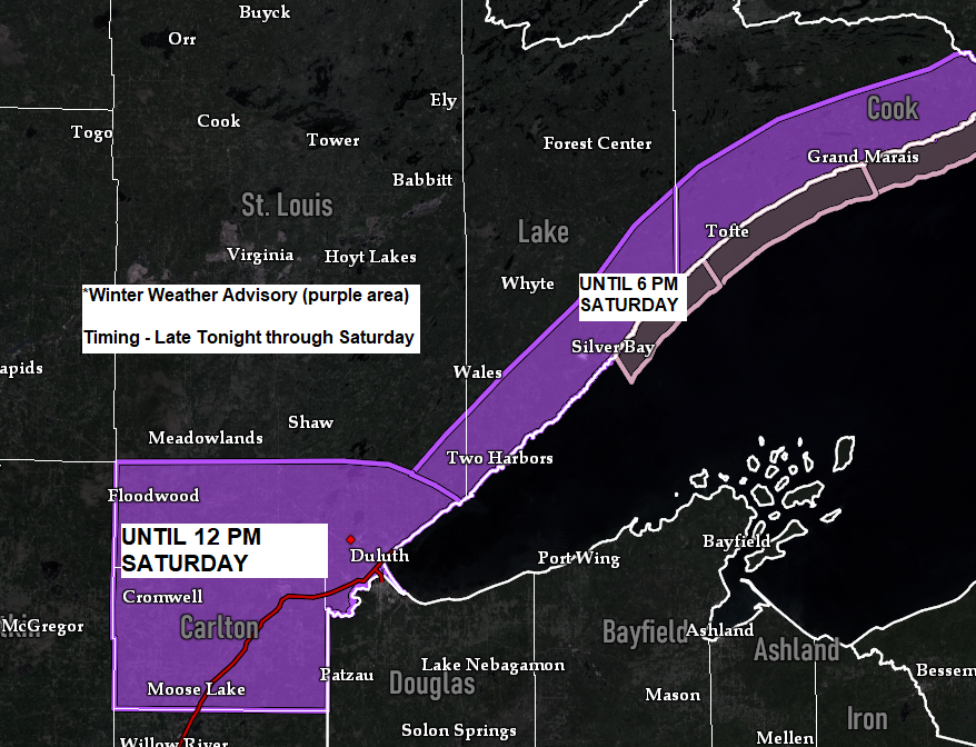
Some snow is on the way for Saturday with the greatest accumulations along the North Shore of Lake Superior where ESE winds crossing the lake will lead to some lake/terrain enhanced snowfall during the day on Saturday.
Snow will taper off from west to east late Saturday afternoon/evening.
Note – Patchy freezing drizzle is also possible across the Northland beginning later tonight, and then continuing on Saturday and into Saturday night.
Highs on Saturday will be close to the freezing mark (31 to 34 degrees) so the snow on Saturday will likely be wetter compared to the snow we saw earlier this week which was very fluffy.
East winds of 10 to 20 mph near Lake Superior could lead to some patchy blowing snow Saturday.
For Duluth – Some snow is likely beginning early Saturday morning (around 4 AM-6 AM) Snow tapers off Saturday evening, although some brief breaks in the snow are possible through the day. Patchy freezing drizzle is also possible in Duluth on Saturday.
18z NAM 3km model radar forecast valid Midnight tonight to Midnight tomorrow night.

Here’s my snowfall forecast for Saturday.
Highest amounts of 3 to 5 inches are expected along the North Shore of Lake Superior (northeast of Duluth)
About 1 to 3 inches of snow is possible in Duluth on Saturday.

Trough responsible in bringing the next round of wintry precipitation to the Northland is crossing the Northern/Central Rockies today.

And here’s a look at the aforementioned trough via Goes-16 water vapor imagery.
Goes-16 water vapor loop from Friday, December 9, 2022.

We’ve seen quite a shift in the storm track for next week but when you look at the 500mb pattern it makes sense as to why we’ve seen the computer models shift the low further south for next week.
There is a lot of ridging setting up across Canada (especially the eastern part) and if this ridge ends up a little further south than modeled, then we could see the low shift even a little more to the south in coming days.
What’s interesting is even with this southern shift, the ensemble models (EPS, GEFS, and CMCE) continue to show a lot of precipitation affecting the Northland with QPF values of 0.50″ to 1.00″+ in much of our area.
For Duluth – Precipitation totals range from 0.90″ to as high as 1.90″ per ensemble model forecasts for next week. If this is mostly snow, then we’re looking at snow totals of around 12″ or more.

It’s a complex pattern, and the storm of interest for the upper Midwest won’t be moving ashore into the Pacific Northwest until Sunday, and then this system will move slowly ENE across the Rockies and into the Central Plains/Midwest during the middle of next week.
This system also continues to slow down which isn’t too unusual given the pattern.
If this storm does hit the Northland it looks like most of the precipitation would occur from Tuesday night through Thursday and breaks in the precipitation are certainly possible due to influences from a dry slot.

We are looking at strong NE winds developing near Lake Superior from Tuesday through Thursday with wind gusts of 25 to 45 mph.
Blowing snow will be an issue if we do indeed see snow next week.
European model wind gust forecast valid 6 AM Tuesday to 6 PM Thursday.

December is off to a very cold start in the Northland and also across the Northern Rockies and Northern Plains.
Warmer temperatures over the next few days will likely eat away at some of the deficits, but likely won’t eliminate them totally.
Average Temperature and Departure from Normal in the Northland for December 2022 (thru the 8th)
International Falls, MN: 3.8 F; -12.7 degrees below average
Hibbing, MN: 6.7 F; -9.6 degrees below average
Duluth, MN: 11.9 F; -9.1 degrees below average
Brainerd, MN: 13.7 F; -7.4 degrees below average
Ashland, WI: 16.4 F; -7.6 degrees below average
Temperature Anomaly for the Lower 48 for December 2022 (thru the 8th)
Green, Blue and Purple – Below Average
Orange – Above Average

We’re still looking at a much colder pattern returning leading up to Christmas.

Thanks for reading!
Tim
Leave a Reply