7:51 PM Thursday, December 15, 2022
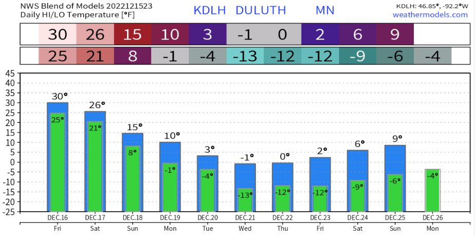
-Colder temperatures are on the way but it will be a slow process. Temperatures Friday will remain on the mild side for mid-December with highs around 30 to the lower 30s, this will be followed by cooler temperatures this weekend with highs in the 20s Saturday, and in the teens to lower 20s Sunday. Even colder temperatures are expected next week as arctic air moves in with a chance for several nights of subzero temperatures in the Northland, with even a chance for subzero daytime highs on a few days next week.
-Snow continues at times thru Saturday morning with a few more inches of accumulation expected.
*Snowfall storm total of 22.7 inches from early Wednesday morning thru 4 PM Thursday at the National Weather Service in Duluth, Minnesota (on top of the hill)
*Daily precipitation and snowfall records were set in Duluth today, with 0.75 inches of precipitation (previous record for December 15 — 0.71 inches set in 1927) And a snowfall total of 10.9 inches (previous record for December 15 — 7.2 inches set in 1974)
*30.3 inches of snow in Duluth so far this month, this is 337% of normal to date.
*Snowiest December on record in Duluth was set in 1950 with 44.3 inches of snow.
22.7 inches of snow in Duluth over the past 48 hours makes this the 8th largest storm of all-time. Note — Official snow stats for Duluth are taken at the National Weather Service which is located on top of the hill. Snowfall totals with this storm were significantly less closer to Lake Superior (lower elevation)

Snowfall totals varied considerably in and around the Twin Ports with this week’s winter storm, with amounts as high as 27 inches reported near Gary New Duluth, Minnesota to 6.5 inches in French River, Minnesota.

| Snowfall Reports for the December 13-15, 2022, Winter Storm Source: NWS Duluth, MN Finland, MN: 29.0″ 2 NNW Gary New Duluth, MN: 27.0″ 5 SE Wales, MN: 27.0″ Chisholm, MN: 24.0″ 2 W Rice Lake, MN: 23.8″ 3 NNE Duluth, MN: 23.5″ 2 SSW Brimson, MN: 23.5″ 4 WNW Delta, WI: 23.5″ 3 NNE Finland, MN: 23.0″ 4 NW Palmers, MN: 21.5″ Silver Bay, MN: 21.2″ 2 N Lutsen, MN: 21.0″ 3 WSW Proctor, MN: 20.0″ 2 NNE Proctor, MN: 19.8″ South Range, WI: 19.5″ 2 S Munger, MN: 19.0″ 6 SSE McKinley, MN: 19.0″ Wrenshall, MN: 18.7″ 4 WNW Red Cliff, WI: 18.7″ 1 N Cloquet, MN: 18.5″ 3 NNW Mahtowa, MN: 18.2″ 9 NNE Lutsen, MN: 18.0″ Hoyt Lakes, MN: 18.0″ 3 W Duluth, MN: 18.0″ 8 W Hovland, MN: 18.0″ Drummond, WI: 17.0″ Finlayson, MN: 16.9″ 4 NW Minong, WI: 16.3″ Moose Lake, MN: 16.0″ 3 N Maple, WI: 16.0″ 1 ESE Nisswa, MN: 16.0″ 1 SSE Oulu, WI: 15.9″ 3 ESE Moose Lake, MN: 15.6″ 2 SW Two Harbors, MN: 15.5″ 1 E Spooner, WI: 15.0″ 12 N Grand Rapids, MN: 15.0″ 4 WNW Washburn WI: 14.5″ 2 SW Coleraine, MN: 14.0″ 1 W Grand Rapids, MN: 14.0″ 5 SSE Libby, WI: 13.9″ 4 S Tower, MN: 13.8″ 2 ESE Deerwood, MN: 13.5″ Oulu, WI: 13.0″ 6 NE Hertel, WI: 12.9″ 2 SSW Ely, MN: 11.7″ Mizpah, MN: 11.5″ 5 W Pine Center, WI: 11.0″ 4 SSW Superior, WI: 11.0″ 7 WSW Hovland, MN: 10.8″ 3 SW Ashland, WI: 10.5″ Ely, MN: 10.3″ Two Harbors, MN: 8.0″ Gile, WI: 7.0″ 1 SW Gary New Duluth, MN: 6.8″ 6 S Whipholt, MN: 5.5″ |
POWER OUTAGE UPDATE
Minnesota Power — 325 active outages affecting 9,414 customers.

Lake Country Power — 496 outages affecting 11,187 members.

What a massive storm as it stretches from the Dakotas to Ontario and Quebec, then all the way south to Florida and to the Gulf of Mexico.
Goes-16 infrared loop from Thursday, December 15, 2022 (loop time ends 7:20 PM)

We’re not quite done yet with the snow associated with this week’s storm.
Low pressure over the Twin Cities this afternoon will continue to lift slowly NE reaching the Keweenaw Peninsula by around daybreak on Saturday.
Occasional snow/snow showers will rotate around this system through Saturday.

18z NAM 3km model radar forecast thru 6 AM Saturday.

Additional snowfall accumulations of 1 to 2 inches are expected in much of the Northland thru Saturday morning, but higher amounts in that 2-to-4-inch range are possible near Lake Superior including for Duluth.

Thanks for reading!
Tim
Leave a Reply