4:16 PM Sunday, December 18, 2022
Some more snow is on the way for Monday afternoon/Monday night as a weak area of low pressure moves northeast out of western Iowa while a trough moves east out of the northern Plains.
Precipitation totals with Monday’s system will remain on the light side with limited moisture available for this system to work with, but with a much colder air mass now in place, this should lead to a fluffier snowfall with higher snowfall ratios on the order of 15:1 to around 21:1, so even light amounts of precipitation should still give us a few inches of snow due to the higher snow ratios with this system.
Also of note will be the wind direction which will shift to the east-southeast Monday afternoon into Monday evening, this should lead to several hours of lake enhanced snow potential along the North Shore of Lake Superior where a winter weather advisory has been issued.
But before the snow arrives later Monday, we’re looking at a very cold night in the Northland with lows tonight in the single digits and teens below zero with some 20s below possible in northern Minnesota.
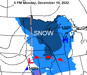
Timing of Monday’s snow
Monday morning looks mainly dry across the Northland and then will see snow develop from SW-NE Monday afternoon into early Monday evening. Snow tapers off by late Monday night.
For Duluth — Snow develops late Monday afternoon (between 3 PM and 5 PM) with snow coming to an end late Monday night (between 11 PM and 1 AM) Total snowfall accumulations of 1 to 3 inches.
18z NAM 3km model radar forecast valid 12 PM Monday to 6 AM Tuesday (snow in blue)

Here’s my snowfall forecast for Monday afternoon/night (ending 1 AM Tuesday)

Widespread bitterly cold arctic air covered Alaska into western and central Canada today with temperatures in the -20s and -30s, with even a few -40s in far northwest Canada and far eastern Alaska. This air mass is heading south/east over the next several days and should reach the Northland mid to late week leading to daytime highs only in the single digits below to around 10 above zero, with low temperatures in the single digits, teens and 20s below zero. Dangerously cold wind chills are also expected in the Northland later this week with values of -15 to around -35 below zero.

Snow stats
Duluth, Minnesota
Snowfall total for December 2022 (thru the 17th) 37.4 inches — compared to 9.8 inches of snow in December 2021 (thru the 17th)
Snowfall total since October 1, 2022 — 55.4 inches — compared to 15.3 inches of snow by this time last year from October 1 to December 17.
Note: We’re running +27.1″ above normal in snowfall this month in Duluth, and +28.2″ above normal for the season.
A look at seasonal snowfall totals since October 1, 2022.

More snow mid to late week?
Will see a strong trough and area of low-pressure dig SE out of western Canada and through the Midwest, Ohio Valley and eastern Great Lakes from mid to late week (December 21-24)
Currently it looks like the greatest snow accumulations with this system will setup farther south/east of the Northland, but some snow accumulation is still possible in northeast Minnesota and northwest Wisconsin mid to late week, with more significant snow amounts possible along the South Shore of Lake Superior in northwest Wisconsin due to possible lake enhanced snowfall for a few days later next week.
The GFS and GEFS models continue to be much farther south with the system for later this week with only a couple of the GEFS members far enough north which would bring some snow to parts of the Northland.
The UK, Canadian, Euro and German-Icon models continue to show a more favorable trough/low placement resulting in a more significant snow event at least for northwest Wisconsin and also for far eastern Minnesota mid to late week.
GEFS model 20-member precipitation forecast valid for Midnight Thursday, December 22, 2022.
Snow in blue

Euro ensemble or EPS model continues to highlight much of Wisconsin and upper Michigan for the greatest chances for 6 inches or more of snow mid to late week, with the lowest chances over the western half of Minnesota.
Far eastern Minnesota including Duluth and western Wisconsin are in that middle zone, in between the highest and lowest chances for 6 inches or more of snow.

A tightening pressure gradient between a deepening low well to our SE and a strong arctic high approaching from the NW could lead to a few days of strong north to northwest winds from Thursday through Saturday with a chance for wind gusts of 25-35+ mph.
Blowing snow could become an issue later this week if these wind gusts verify, and the blowing snow potential would increase even more if we do get some new snow mid to late week.
European model wind gust forecast valid 6 AM Thursday to 6 PM Saturday.

Thanks for reading!
Tim
Leave a Reply