6:13 PM Tuesday, December 20, 2022
A variety of weather impacts likely the next few days.
*Snow
*Blowing Snow
*Strong Winds
*Scattered Power Outages
*Frigid Temperatures and Wind Chills
*Occasional Whiteout/Blizzard Conditions
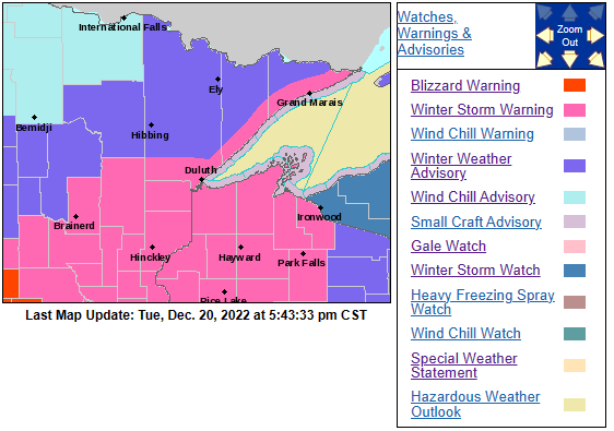
*Winter Storm Warnings and Advisories cover all of northeast Minnesota and northwest Wisconsin from Wednesday through Saturday. Travel could be very difficult. Areas of blowing snow could significantly reduce visibility.
Breaking it all down

SNOW WEDNESDAY-EARLY THURSDAY
Snow is forecast to begin in western/southern portions of the Northland Wednesday morning. Snow spreads farther north/east Wednesday afternoon. Snow tapers off from SW-NE late Wednesday night-Thursday morning, but lingering lake effect snow is likely along the South Shore of Lake Superior in northwest Wisconsin Thursday through Saturday.
Some additional snow showers and flurries are also expected in northeast Minnesota and for areas away from Lake Superior in northwest Wisconsin Thursday afternoon through Saturday, but little additional accumulation is expected.
For Duluth — Snow begins between 11 AM and 1 PM Wednesday. Snow diminishes between 1 AM and 4 AM Thursday. A few lingering flurries and snow showers are possible Thursday through Christmas Eve (Saturday)
18z NAM 3km model radar forecast valid from 6 AM Wednesday to 6 PM Thursday.

Here’s my snowfall forecast through 6 PM Saturday.
Note — The bulk of the accumulations shown on the map below will fall by 6 AM Thursday, with the exception to this being in northwest Wisconsin, especially along the South Shore of Lake Superior where lake effect snow is likely to continue through Saturday. Snow will also linger longer over the Arrowhead of Minnesota in that 7 to 10″ zone.
Bust Potential — With such a cold air mass already in place, snowfall ratios per model guidance look to be on the high side, running in that 18:1 to 25:1 range, but also with the arctic air over the area, this may lead to real small snowflakes which take much longer to pile up/accumulate compared to larger dendrites (snowflakes) If the snowflakes remain relatively small on Wednesday, then snow amounts will probably end up on the lower end of the forecasted range on the Minnesota side, and for areas away from the South Shore in northwest Wisconsin.
For Duluth — Total snowfall accumulations of 4 to 7 inches are possible by 6 AM Thursday. Little additional snowfall accumulation is expected after 6 AM Thursday.
Snowiest December on record at Duluth is 44.3″ set in 1950. So far this month we’ve had 40.4″ of snow. There is a chance that will set a new monthly snowfall record for December by Thursday.

STRONG WINDS AND BLOWING SNOW
North to northwest winds will increase on Thursday to 10 to 20 mph with gusts to 30 mph, but the strongest winds in the Northland are expected to occur from late Thursday night through Saturday, this is when we could see wind gusts of 30 to 45 mph, with even stronger gusts to 60 mph possible along the North Shore of Lake Superior in northeastern Minnesota.
NAM 850mb wind forecast valid 12 PM Thursday to Midnight Saturday.
Note – The red and purple colors represent winds of 50 to 70 knots at 850mb or up around 5000 feet in the atmosphere.

Blowing snow will become a bigger issue as we get into Thursday, but especially from Friday into Saturday as winds increase late this week. Occasional whiteout and even blizzard conditions are possible especially near Lake Superior.
European model wind gust forecast valid from 6 AM Thursday to 6 PM Saturday.

BITTERLY COLD TEMPERATURES
A large area of bitterly cold temperatures stretched from Alaska into much of western-central Canada, south to the northern Rockies, northern Plains and upper Midwest today.
Temperatures were in the -40s and -50s this afternoon in parts of Alaska and northwest Canada to the -20s in parts of North Dakota.

Low temperatures in the -10s and -20s will be common in the Northland tonight with a few -30s possible in northern Minnesota (typical cold spots)

*Wind Chill Advisory (light blue are) in effect until 10 AM Wednesday for all of northeast Minnesota and northwest Wisconsin.
-Very cold wind chills expected.
-Wind chills as low as 30 below zero.

Snowfall Reports from Monday, December 19, 2022
Source: National Weather Service Duluth, Minnesota
7 WSW Hovland, MN: 7.4″
New Post, WI: 4.5″
5 S Herbster, WI: 4.3″
3 E Sand Bay, WI: 4.1″
Gile, WI: 4.0″
Mason, WI: 4.0″
Ashland, WI: 3.7″
Butternut, WI: 3.5″
2 SE Spooner, WI: 3.2″
1 SSE Two Harbors, MN: 3.0″
1 N Cloquet, MN: 3.0″
Duluth, MN: 3.0″ (Official total at the NWS)
1 W Solon Springs, WI: 2.9″
3 N Amnicon Falls State Park, WI: 2.9″
Mellen, WI: 2.8″
2 SSW Cloquet, MN: 2.7″
1 S Hibbing, MN: 2.7″
Grand Rapids, MN: 2.5″
2 SSW Ely, MN: 2.0″
3 ENE Holyoke, MN: 2.0″
1 SW Brainerd, MN: 1.0″
Thanks for reading!
Tim
Leave a Reply