5:24 PM Tuesday, January 3, 2023
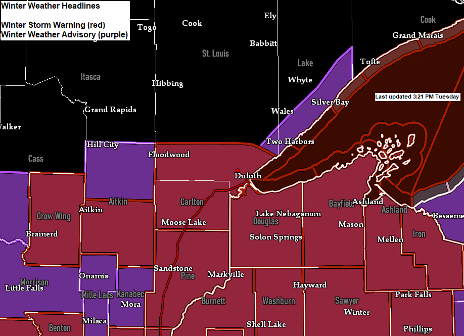
Updated Winter Weather Headlines as of late Tuesday afternoon
-Winter Storm Warning for all of northwest Wisconsin.
-Winter Weather Advisory upgraded to a Winter Storm Warning farther west to include Duluth, Cloquet, Moose Lake, Aitkin and Brainerd.
-Winter Weather Advisory issued for northern Aitkin County including Hill City, and also for southern Lake County including Two Harbors and Silver Bay.
These winter weather headlines are in effect through Wednesday afternoon.


- Light to moderate snow with occasional bursts of heavy snow will continue in east-central Minnesota, Twin Ports and northwest Wisconsin through Wednesday evening.
- Patchy freezing drizzle (light icing) is possible at times when snowfall rates diminish.
- Areas of blowing snow through early Thursday morning with occasional whiteout conditions possible especially near Lake Superior.
- NE winds will continue to increase near Lake Superior tonight with wind gusts of up to 40 mph, with even higher wind gusts possible on Wednesday of around 45 to 50 mph.
Here’s my updated snowfall forecast through 6 AM Thursday
6 to 8 inches of snow for Duluth, with a swath of 8 to 12 inches of snow just to the south.
A sharp snowfall gradient is likely on the northern side of this system.
Note — Snow totals could exceed the 6-to-8-inch mark in Duluth especially if we see more lake effect/lake enhanced snowfall, and that remains a possibility through Wednesday evening as winds will be out of the northeast.

We likely won’t see the snow taper off in eastern Minnesota and northwest Wisconsin until sometime late Wednesday night or Thursday morning.
Snow that falls through early Thursday shouldn’t be quite as heavy as what we’ve seen late this afternoon but expect at least a steady light to at times moderate snow, with perhaps some heavier lake effect snow near Lake Superior, but temperatures continue to look a little marginal for more robust lake effect snow, with 850mb temperatures likely holding in the -3 to -5C range through Wednesday evening.
18z NAM 3km model radar forecast through 12 PM Thursday,

Winds near Lake Superior peak late tonight through the day Wednesday as will see northeast winds gusting 30 to possibly as high as 50 mph, so even light snow in that type of wind should lead to poor visibilities at times.
HRRR model wind gust forecast through 7 AM Thursday.

Plenty of moisture surging NW out of southern Minnesota and Wisconsin today with PWATS of around 0.50 inches in eastern Minnesota to as high as 0.80″ in eastern Wisconsin, but much drier air with PWATS <0.25″ remain in place across northern Minnesota and this dry air should keep that area mostly snow-free through the duration of this winter storm.

Big time temperature contrast helping to fuel our latest winter storm with temperatures this afternoon ranging from the single digits and 10s in North Dakota and northwest Minnesota to the 50s and 60s across portions of the Midwest and Ohio Valley, including a 70-degree temperature at St. Louis, Missouri at 4 PM today.

Another complex setup this week with a building ridge off to our northwest, while we have two upper lows, one east of Hudson Bay Canada, the other over eastern Nebraska.
The upper low over eastern Nebraska won’t be in a hurry to move on out, in fact it won’t be until Thursday until we see that low exit off to our east.

500mb Forecast through 6 AM Thursday per RAP model.
Notice how the upper low basically stalls out along the Minnesota-Iowa border area through the day Wednesday before the upper low exits off to the east.

A look at the winter storm impacting parts of the upper Midwest today via Goes-16 water vapor imagery.
Goes-16 water vapor loop from Tuesday afternoon, January 3, 2023.

Thanks for reading!
Tim
Leave a Reply