6:10 PM Monday, January 23, 2023
Busy winter pattern this week as will see a strong low lift NE out of northern Mexico/far south Texas on Tuesday reaching the Ohio Valley by Wednesday evening, while a clipper system moves southeast out of Alberta and across the upper Midwest Tuesday night-Wednesday.
The low coming out of Mexico won’t affect our weather in the Northland, but the system coming out of western Canada will bring a long duration but mostly light snow event to much of the Northland with this snow beginning late Tuesday afternoon or Tuesday evening and then continuing through the day Wednesday before ending Wednesday night.
BRIEF SNOW SQUALLS TONIGHT
Locally heavy snow showers/squalls will move east-southeast across portions of the Northland tonight. These showers won’t last long but the snow could reduce visibility to <1 mile for brief periods of time tonight.
New snowfall accumulations should be around an inch or less tonight.
Increased risk for snow squalls this evening in northern Minnesota as evident by the lighter blue and purple colors on the image below.

18z NAM 3km model radar forecast through 9 AM Tuesday.

Snow overspreads the Northland from west to east late Tuesday afternoon/evening with some lake effect snow showers possible along the North Shore of Lake Superior during the day Tuesday as winds shift to the east to southeast.
Note — Looks mainly dry in Duluth during the day Tuesday with snow arriving Tuesday evening (between 5-7 PM) Snow ends Wednesday night. Total snowfall accumulations of 1 to 3 inches from Tuesday evening through Wednesday.
18z NAM 3km model radar forecast valid 9 AM Tuesday to 9 PM Wednesday.

Snowfall through Thursday morning per NWS forecast.

A major pattern change is on the way!
Arctic air has been severely lacking for about a month now, but that will be changing in a big way this weekend into next week (and possibly beyond)
An upper-level low (polar vortex) will position itself near Hudson Bay Canada with lobes of frigid air breaking off that upper low while dropping south/east through the northern Plains and upper Midwest this weekend into next week.
The main storm track will likely be well south of our area, however, due to this arctic air next week, so at the moment it doesn’t look like will be seeing much snow in our area next week.

Mild temperatures continue through Friday, but after that it’s all about the cold temperatures with daytime temperatures mostly in the single digits below to single digits above zero in the Northland from this weekend through next week, with overnight temperatures in the -10s and -20s with some -30s possible as well.

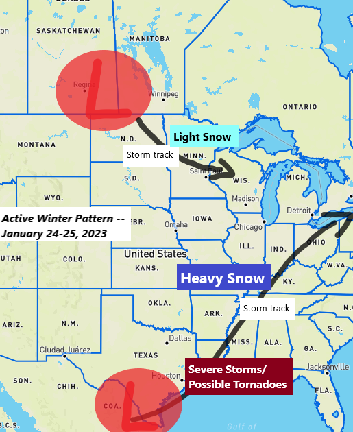
A winter storm will track from the southern Rockies and High Plains to the northeast U.S. over the next few days. Heavy snow and some wind along and north of the storm track, while severe thunderstorms and a risk for some tornadoes will be found in the warmer air across the Deep South.
Severe thunderstorms are expected Tuesday into Tuesday night from southeast Texas to the southern half of Louisiana into southern Mississippi and southern Alabama. Tornadoes and damaging winds are the primary severe weather threats on Tuesday, and a few of the tornadoes could be on the strong side.


NWS Snowfall Forecasts


Thanks for reading!
Tim
Leave a Reply