6:21 PM Wednesday, March 8, 2023
*Areas of light snow and flurries will persist across parts of the Northland tonight, but no major impacts are expected as snowfall amounts remain under an inch.
*There is a greater chance for some slippery road conditions Thursday afternoon, but more so Thursday night into Friday morning due to the potential for some accumulating snow as well as cooler temperatures which should allow for the snow to accumulate on the roads. We’ve reached that part of the winter where it might be snowing but not really accumulating on the roads due to the higher sun angle that we have at this time of year which is why the impacts to road conditions are greater at night and during the morning compared to during the afternoon when we’re still able to get some warmth from the sun due to the higher sun angle at this time of year. Of course, this all changes if snowfall rates are heavy enough (1″+/hour) then it really doesn’t matter about the sun angle as snow would still be able to stick to the roads during the afternoon hours.
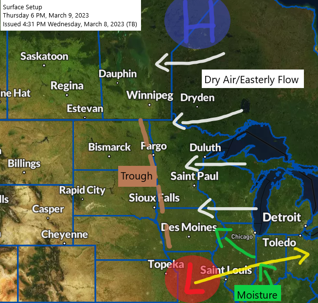
*The battle will be on between the massive amounts of dry air pumping south out of Canada while moisture attempts to push far enough to the north into the Northland to produce some snow Thursday afternoon-Friday morning. Will see which one ends up winning.
*Low chance that will get some lake enhanced snowfall near Lake Superior including in the Twin Ports which could boost snow amounts just a bit Thursday night/Friday as 850mb temps will be sitting at around -10 to -11C, winds also look favorable for lake enhanced snow (ENE direction)
*Northeast winds will increase near Lake Superior with gusts of 20 to 35 mph Thursday afternoon into Friday morning. Patchy blowing snow is possible due to these gusty winds.
*Another chance for snow Saturday afternoon through Sunday night as a clipper type system passes through the upper Midwest, but I’m not sold yet on the outrageous amounts of snow the computer models are cranking out for the system this weekend, and the main reason for that is due to this being a clipper system which rarely produces more than 4″ of snow. The track of the system for this weekend could also shift either farther north or south the next few days. Stay tuned.
Here’s my updated snowfall forecast through Noon on Friday.
For Duluth: 1 to 3 inches of snow is possible through 12 PM Friday.

HRRR model wind gust forecast valid 7 AM Thursday to 12 PM Friday.

Will continue to see some areas of light snow in parts of the Northland tonight, then possibly a break Thursday morning before some more snow approaches from the south Thursday afternoon/evening, but this snow should mainly affect southern portions of the Northland including areas along and south of Highway 2 in northeast Minnesota including most of northwest Wisconsin. Snow tapers off late Thursday night/Friday morning the way it looks now.
NAM 3km model radar forecast through 12 PM Friday.

The pattern continues to be an active one, but one big thing we’ve seen develop this week is massive ridging to our north across central/northeast Canada, and this ridge more or less stays in place into next week, although perhaps not quite as strong as what we’re seeing now. So, although the pattern remains active, there is no guarantee will be getting a whole lot of precipitation in the Northland as that will come down to individual storm tracks, and with that ridge sitting off to the north it’s possible that the majority of these systems miss us to the south through late next week.
We’re seeing a wavenumber 5 pattern develop next week where there’s basically 5 systems rotating around each other, or around the strong ridge in central/northeast Canada.

A strong temperature gradient in place over Texas today with temperatures in the 40s to lower 50s in parts of north Texas with 80s farther to the south.
Sufficient amounts of elevated instability in the colder air (outlined in black) have led to scattered elevated strong to severe thunderstorms with a threat for large hail in parts of north Texas today.

Radar image of the storms in north Texas late today.

GR2 radar analyst volume explorer image of the storms in north Texas late today.


And finally, here’s the sandwich satellite loop of the storms (orange and reds on the loop below) in north Texas from Wednesday, March 8, 2023 (loop time ends 4:51 PM CT)

Thanks for reading!
Tim
Leave a Reply