6:33 PM Friday, March 17, 2023
*Snow showers possibly heavy at times will continue to move S/SE across the Northland tonight as a strong mid/upper-level low moves east across Lake Superior.
*Lingering snow showers Saturday morning mainly along the South Shore of Lake Superior in northwest Wisconsin, but the rest of the Northland should be dry Saturday, and the entire Northland looks dry on Sunday.
*March 2023 currently ranks as the 7th snowiest March on record in Duluth with 28 inches of snow so far this month (thru 4 PM on the 17th) Snowiest March on record was in 1917 with 48.2 inches of snow.
*35-inch snow depth at the National Weather Service in Duluth, MN as of 7 AM March 17th.
*Coldest day of the weekend will be Saturday, but there should be some sun to at least make it feel somewhat warmer during the afternoon.
*Blustery northwest winds continue tonight and Saturday with wind gusts of 20 to 35 mph. Patchy blowing snow will also continue due to the gusty winds tonight.
*Active pattern continues next week with a few chances for snow or mix precipitation.
Snow showers should be most widespread and heaviest this evening followed by more scattered coverage snow showers and flurries overnight through Saturday morning.
NAM 3km model radar forecast through 1 PM Saturday.

Additional snowfall accumulations tonight through 1 PM Saturday.

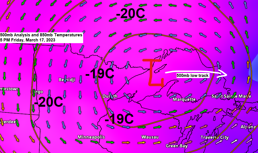
Here’s a look at the storm which continues to impact the Northland this afternoon as a strong surface and mid/upper-level low moves slowly north/east across Lake Superior and Ontario.
Goes-16 infrared satellite loop from Friday, March 17, 2023 (loop time ends 5:40 PM CT)

Water vapor loop from Friday, March 17, 2023 (loop time ends 5:50 PM CT)

More snow and possibly some mix precipitation possible next week, but chances for a major winter storm look pretty low at this time, with more of a light to possibly moderate type of snow event possible sometime mid to late next week.
Highest chances for 3 or more inches of snow covers eastern portions of the Northland mid to late next week with lower chances the farther west you go.

Probabilities for 6 or more inches of snow are highest near Lake Superior for mid to late next week with lower chances farther west.

There remains quite a bit of uncertainty, however, with timing, as well as the track/strength of low-pressure systems for next week, and the storm track and temperatures will determine whether or not we get snow or rain or a bit of both in the Northland. Stay tuned.
GEFS 20-member precipitation type forecast for 1 AM Wednesday, March 22, 2023.
Snow (blue)
Rain (green)
Wintry Mix (pink)

And here’s a look at the GEFS model 20-member precipitation type forecast for 1 PM Thursday, March 23, 2023.
Snow (blue)
Rain (green)

A late season arctic airmass covered the northern Plains and upper Midwest today with temperatures this afternoon only in the single digits and teens in North Dakota to the teens in northeast Minnesota and northwest Wisconsin. Note — Normal highs on March 17th are in the mid 30s to around 40 degrees in the Northland.

Temperatures this afternoon were running anywhere from -20 to -30 degrees colder than average from the Dakotas to central Wisconsin.

No signs that will be seeing temperatures of 50 degrees or warmer anytime soon in northeast Minnesota and northwest Wisconsin.
Here is the EPS model probability for high temps of 50 or warmer through March 31st.
Highest probabilities (blue colors on loop below) for temps of 50 or warmer are over southern Minnesota on a few days through March 31st.

Tim
Leave a Reply