5:51 PM Wednesday, March 22, 2023
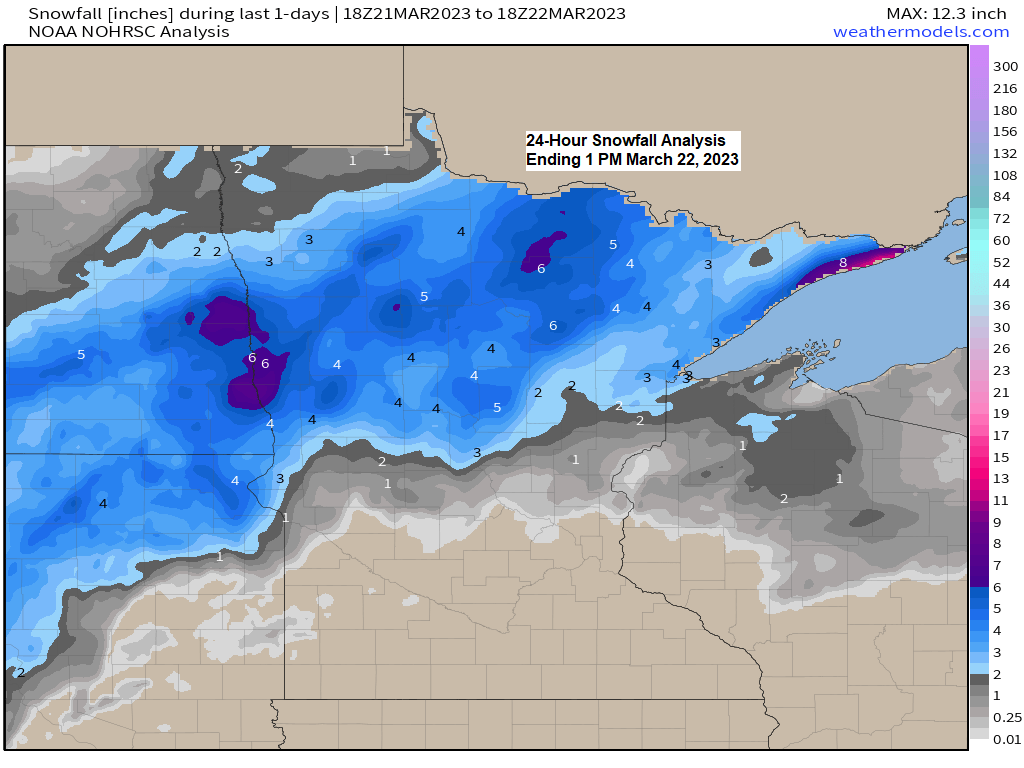
Snowfall Reports from March 21-22, 2023
Source: National Weather Service Duluth, Minnesota
4 W Grand Marais, MN: 12.1″
3 NW Hovland, MN: 8.2″
Silver Bay, MN: 7.6″
1 SSE Hibbing, MN: 7.0″
3 WSW Grand Marais, MN: 7.0″
1 NNW Marcell, MN: 6.9″
3 WSW Lutsen, MN: 6.5″
3 SSE Coleraine, MN: 6.0″
6 WNW Castle Danger, MN: 6.0″
12 N Grand Rapids, MN: 6.0″
Coleraine, MN: 5.9″
2 N Warba, MN: 5.5″
1 NW International Falls, MN: 5.5″
8 E International Falls, MN: 5.5″
3 SW Lester Park, MN: 5.5″
Cook, MN: 5.1″
Keewatin, MN: 5.1″
Federal Dam, MN: 5.0″
7 NNW Two Harbors, MN: 5.0″
3 E Orr, MN: 4.8″
Chisholm, MN: 4.7″
2 ESE Duluth, MN: 4.5″
1 SW Brainerd, MN: 4.5″
2 NNW Gary New Duluth, MN: 4.5″
1 WNW Ely, MN: 4.5″
1 SW Grand Rapids, MN: 4.5″
5 NE Hackensack, MN: 4.3″
3 NE Brainerd, MN: 4.1″
2 N Pillager, MN: 4.1″
1 E Lester Park, MN: 4.0″
1 SW Lester Park, MN: 4.0″
6 S Tower, MN: 4.0″
Embarrass, MN: 4.0″
2 WNW Duluth, MN: 4.0″
7 SSW Deerwood, MN: 3.7″
2 WSW Superior, WI: 3.6″
6 SSW Ely, MN: 3.5″
Duluth, MN: 3.3″ (Official total at the NWS)
2 S Brimson, MN: 3.2″
Lester Park, MN: 3.0″
Two Harbors, MN: 2.9″
3 SW Bayfield, WI: 2.8″
4 NE Palisade, MN: 2.6″
5 NE Silver Bay, MN: 2.5″
2 SW Bayfield, WI: 2.5″
1 WSW Maple, WI: 2.3″
5 SSE Libby, MN: 2.2″
3 NNW Mahtowa, MN: 2.2″
5 S Herbster, WI: 2.0″
4 SSW Shell Lake, WI: 2.0″
Wrenshall, MN: 2.0″
1 W Solon Springs, WI: 1.9″
3 N Amnicon Falls State Park, WI: 1.8″
Ashland, WI: 1.7″
1 SW Hayward, WI: 1.6″
25 E Ely, MN: 1.6″
1 N Ashland, WI: 1.5″
3 ESE Moose Lake, MN: 1.1″
7 SSE Earl, WI: 1.0″
*32.1 inches of snow so far this month in Duluth, this is +22.4″ above average to date and is 331% of normal snowfall to date. If the month ended today March 2023 would finish as the 3rd snowiest March on record. The snowiest March on record occurred in 1917 with 48.2 inches of snow, the 2nd snowiest March on record occurred in 1965 with 45.5 inches of snow.
*The seasonal snowfall total for 2022-2023 at Duluth is at 125.4 inches which makes this the 6th snowiest season on record so far. Still need an additional 10 inches of snow to tie the seasonal snowfall record of 135.4 inches set in 1995-1996.
Heavy snow moved quickly northeast across the Northland early this Wednesday morning thanks to an area of low pressure which was over west central Minnesota early today. Here’s a look at that system from earlier today per Goes-16 satellite imagery.
Sandwich loop ending 3:56 AM Wednesday, March 22, 2023.

Water vapor loop ending 4:01 AM Wednesday, March 22, 2023.

Still no signs of any significant or prolonged warmth in Duluth over the next 10 days. Daytime highs generally in the 30s with a chance for a 40-degree day or two through late next week, but overall, a cool pattern continues.
Only 1 day so far this month with a temperature of 40 degrees or warmer in Duluth (March 15th high of 40). Duluth averages 10 days in March with a temperature of at least 40 degrees.
Here’s the list of years where Duluth recorded 0 or just 1 day with a temperature of 40 or warmer in March.
1983: 0
1904: 0
1899: 0
1891: 0
1971: 1
1965: 1
1951: 1
1940: 1
1885: 1
Note — Normal highs in Duluth from March 23rd through April 1st range from 39 to 43 degrees, and the normal lows range from 21 to 24 degrees.

Odds favor more below average temps in the Northland for next week.

GEFS model temperature anomaly trend for next week.
Blues and Purples: Below average temperatures
Orange and Reds: Above average temperatures

Risk for severe thunderstorms the next few days with the risk peaking on Friday.
Isolated large hail events possible with the severe risk tonight from parts of Missouri to north central Indiana.

The threat for severe storms increases on Thursday stretching from southwest to north Texas into southern Oklahoma. Large hail and damaging winds are the primary threats with an isolated tornado also possible.

The threat for severe storms peaks on Friday with numerous severe storms possible including a risk for tornadoes (some strong) large hail and damaging winds. Portions of central/northern Louisiana, southern Arkansas into west central Mississippi are in the highest risk area at this time.

Goes-16 water vapor loop shows an active pattern continuing but the main storm track will setup well south of the Northland at least through early next week.

Tim
Leave a Reply